Local jökulhlaups: when the ice melts
Published 9:30 pm Wednesday, September 6, 2023


July 20, 2011
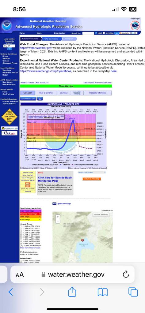
The water level in Mendenhall Lake was rising rapidly, but the usual conditions for flooding were absent. Instead of heavy rain, there was blue sky and sunshine. It was Wednesday, July 20, 2011. Experts from the National Weather Service, the University of Alaska Southeast, and the City and Borough of Juneau alerted the Mendenhall Glacier Visitor Center (MGVC) staff that a glacial outburst flood was occurring in Suicide Basin. Mendenhall Lake was rising 1-2 inches per hour.
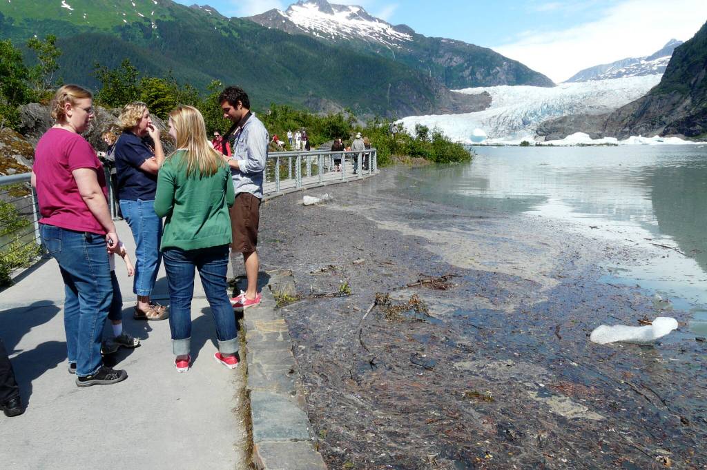
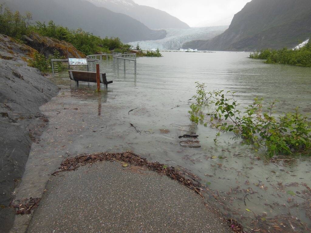
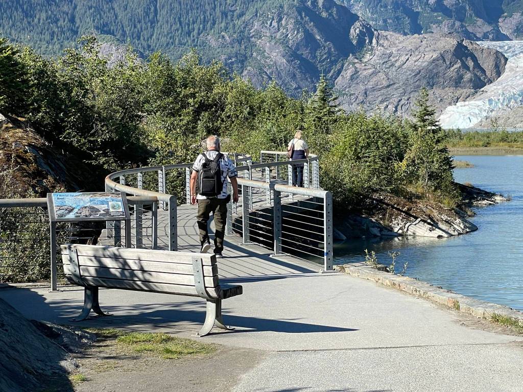
The next day the lake level had risen to within an inch of the foot bridge to Photo Point, peaking at 10.92 feet. The average lake level is about five feet on the U.S. Geological Survey (USGS) measuring gauge located in the northwest corner of the lake. The flood of 2011 was also the first time the MGVC staff was pummeled by the public with questions about where Suicide Basin is located.
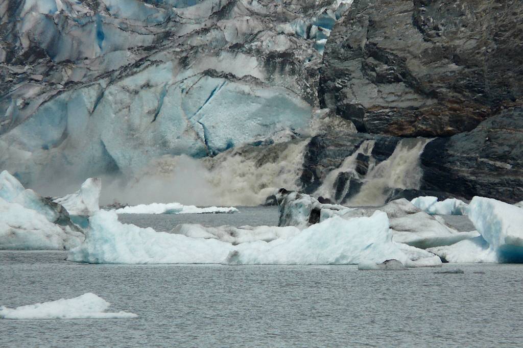
That was the day most Juneauites learned a new word: “jökulhlaup.” This is an Icelandic term for a glacial outburst flood that translates literally as “glacier jumps.” Ice-dammed meltwater floats the glacier and escapes underneath or via side channels adjacent to the ice-bedrock edges.
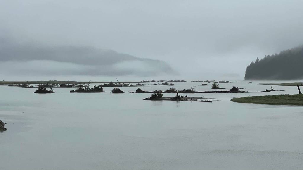
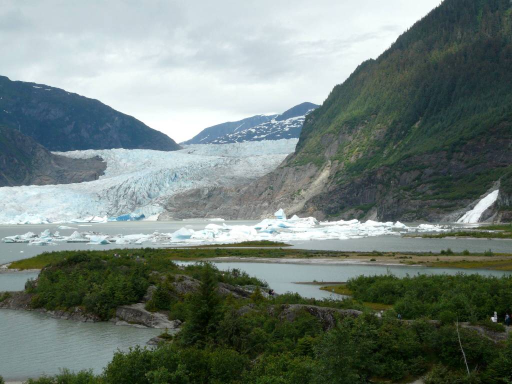
It seemed like everyone was trying to pronounce the new term that was impacting Mendenhall Glacier and its lake (“yok-el-hawp”). Residents flocked to the glacier to witness firsthand what the new phenomenon looked like on familiar terrain. The Steep Creek viewing platforms where they usually watch bears and salmon instead revealed tall cow parsnip plants submerged under lake overflow and icebergs drifting from the lake into the meadow. Mendenhall Lake was rising fast and inundating trails and campsites.
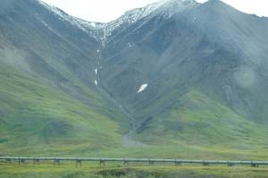
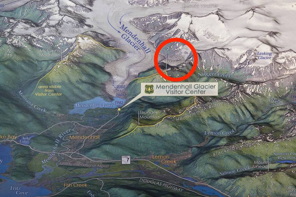
The source was mysterious to many. Hidden behind Bullard Mountain and about two miles up from Mendenhall’s terminus a once-thick glacier has melted into a suspended “hanging” glacier. Its former ice fall was now a waterfall filling Suicide Basin below with meltwater that floated a thick crust of ice. The floating Suicide Basin ice stayed in the basin because the Mendenhall Glacier forms an ice dam blocking basin water drainage.
As the summer temperature warms and the waterfall fills Suicide Basin, the floating cap of ice visibly bulges upward. The basin’s meltwater builds buoyant pressure against the less dense Mendenhall Glacier ice dam, eventually lifting it. Water begins to drain slowly then rapidly increases as it is released beneath Mendenhall Glacier.
The emptying water augurs wider and wider channels increasing the speed of meltwater drainage. The rate of flow skyrockets, quickly raising the level of Mendenhall Lake. When the basin drains below its ability to float the ice dam, the flow slows or ceases and the lake flooding stops.
The experts who explained the phenomena began measuring Suicide Basin depth that year. The biggest challenge was the thick layer of glacial ice that covers the unknown quantity of water beneath it. Researchers needed to learn the volume of the basin, the thickness of the ice on top, and other details to predict when a repeat might occur and determine how much water would flow out.
The origin of the name of Suicide Basin is quite murky. No one knows for sure. It appears to be a recent name with only speculation regarding how it came about. The story is that, in the late 1960s or early 1970s, some local skiers decided to ski down the steep rugged slope that was continuously connected from the icefield over a frozen icefall into what was the solid glacial basin. At the time all was snow-covered ice. The bold, young skiers chided each other that it would be suicide to attempt it. They succeeded, however, and lived to tell about it.
Glacier outburst floods have released from Mendenhall Glacier every summer since 2011 with varying degrees of intensity. Scientists with the university, federal and state agencies, and the city have teamed up to study the processes going on in Suicide Basin. This information will help the Juneau public and the many summer visitors better understand when and how much water will be discharged, and what downstream impacts are likely to occur. This expert collaboration has resulted in early warnings to the public, excellent media coverage, some neighborhood and MGVC access closures, and recommended evacuations such as Mendenhall Campground and certain at-risk properties along Mendenhall River.
Summer 2014
Juneau residents have been learning about this new phenomenon of glacier outburst flooding. A second notable Mendenhall jökulhlaup happened on July 11, 2014. Suicide Basin was being monitored by the USGS Hydrologic Group, the U.S. Weather Service and UAS researchers. Cameras were placed above the basin that showed the surface ice over the summer was expanding upward like a soufflé rising in the oven. And like a soufflé once it’s removed from the oven, the crust collapses. In the case of a jökulhlaup, that’s the effect when the water drains out.
Meanwhile, as Mendenhall Lake was rising in July 2014, a big public event occurred in the middle of the night at the glacier. The nationally televised Today Show broadcast their morning program live from the outdoor pavilion at MGVC. Live-air time was scheduled for 3 a.m. Alaska time in order for East Coast viewers to watch at 7 a.m. The Juneau community was invited to form the audience starting at 2 a.m. Law enforcement officers directed cars as hundreds of Juneauites rushed toward the MGVC pavilion. Broadcasting equipment and the program’s cast filled the open structure while onlookers stood outside the perimeter waving signs for the television audience. Everything went well. By 5 a.m. the live broadcast was successfully completed and the enthusiastic supporters went home.
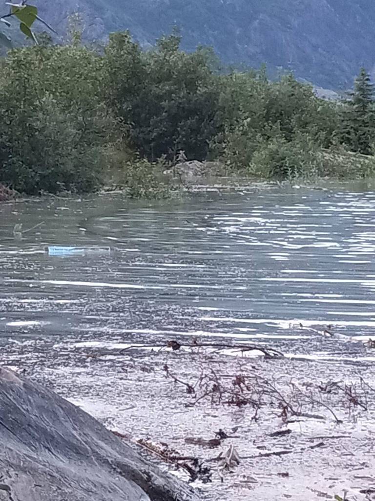
The visitor center staff got some sleep before returning a few hours later to host a typically large crowd of summer visitors. The lake level continued rising, which flooded trails and confined a few thousand guests to limited areas. Water flooded into the forest, inundated the lakeshore and trails, and floated icebergs into unusual places. Confused sockeye salmon swam above the swollen creek bed and mingled with vegetation. When the water went down, the fish returned to their waiting pond near the mouth of Steep Creek. Apparently it was too early to begin spawning. By 1:15 p.m., the lake level flooded over the Photo Point footbridge. Slippery flotsam obscured the surface and caused the bridge to be closed. Three hours later the water level peaked at 11.85 feet. Despite drizzle, a steady stream of vehicles brought people out to the glacier to witness the flood with their own eyes.
Summer 2016 and 2023
The third major jökulhlaup occurred in 2016. On Wednesday, June 29, the release started. The next day there were three significant terminus ice calvings of Mendenhall Glacier: in the morning, at 1:25 p.m. and at 4:15 p.m. On Friday, July 1, 2016 the lake level peaked at 11.99 feet and flooded over the Photo Point footbridge by about eight inches. A glacier ranger marked the maximum water level with blue tape wrapped around the bridge railing support posts. The tape is still visible as a reference point. The 2016 jokulhlaup produced the biggest outburst flood recorded by instruments until the 2023 event broke all records.
When the 2023 jökulhlaup peaked on sunny Saturday, Aug. 5, the lake level reached 14.97 feet. It was three feet higher than 2016. At the glacier, water completely inundated Photo Point footbridge, obscuring the top of the railing. An underground storage structure was flooded despite sandbags stacked at the entrance. Trails were submerged. Creeks flowed backwards. Water sloshed in waves over trails never covered prior to this event.
While the lake level rises steadily in a typical jökulhlaup, everything changes when the extra-full lake drains into the narrow course of Mendenhall River. In 2023 the river water became a churning torrent. By 7 p.m., Juneau police had blocked all vehicle and pedestrian traffic on the Back Loop Road bridge in the upper Mendenhall Valley for safety.
The river’s easily erodible sand and gravel banks disappeared abruptly that night. Residents who had gathered for a “watch party” of this annual natural phenomenon were quickly filled with dread as they watched tall spruce trees tumble into the raging river like collapsing dominoes. Home foundations were eroded leaving buildings dangling unsupported over disappearing river banks. Two homes broke apart and their contents were swept into the roaring water.
Farther downstream, along the Airport Dike Trail, big trees wedged between pilings supporting the airport’s landing lights as more spruce and hemlocks flushed down the river toward Gastineau Channel, Stephens Passage and beyond. Some debris swung around the end of Mendenhall Peninsula and floated into Auke Bay. Personal items that had been washed out of crumbling homes were discovered later on North Douglas beaches. Many trees became embedded in sediments at the river mouth making an eerie graveyard of protruding roots and trunks.
Fortunately, no lives were lost. Damage is still being assessed as the Juneau community and government officials struggle to understand how those three additional feet of water in Mendenhall Lake could create such havoc.
Scientists who have been studying Suicide Basin since 2011 are developing techniques to predict the magnitude and timing of future Suicide Basin glacial outburst floods. Their report titled “Deglacierization of a Marginal Basin and Implications for Outburst Floods, Mendenhall Glacier, Alaska,” was published in the May 2020 issue of Frontiers in Earth Science. The report analyzes data collected from the 2018 and 2019 jökulhlaups. In 2018 the floating ice in Suicide Basin averaged over 100 feet thick. The following year, the floating ice had thinned which increased the capacity for water. While the general process of ice dam formation and release is understood, the specifics are difficult to discern because most activity occurs out of sight under tons of glacial ice. More study is needed.
•••••
Other Alaska Jökulhlaups
Glacial outburst floods have occurred frequently in other places in Alaska and globally. Regionally there are two locations near Juneau that are renowned for their floods: Taku River and Hubbard Glacier. The U.S. Geological Survey’s Hydrology Branch researchers monitor these rivers and annually collect water discharge data.
Taku River
Taku River experiences yearly jökulhlaups when a glacially dammed lake drains beneath Tulsequah Glacier in British Columbia, 30 miles northeast of Juneau. Its name perfectly describes the event and location: Lake No Lake. When the lake empties it resembles an emptied bathtub with all the toys piled at the drain. Instead of imagined rubber duckies, the emptied lake is heaped with giant icebergs from Tulsequah Glacier.
Juneau’s National Weather Service issues flood warnings about the pending Taku River jökulhlaup because the impact affects commercial fishermen, cabin owners and tour operators. The rush of draining water scours river banks and islands. The surge floats trees and occasionally untethers remote cabin docks. Silty glacial water has been known to flow into downtown Juneau’s harbor turning the water an unusual shade of aqua.
Similarly to Mendenhall’s 2023 massive outburst flood, Taku River saw a much larger than normal flood two years ago. On June 30, 2021, several factors combined to make the largest jökulhlaup in recent history when the river flood peaked at 45.54 feet. By late June the rapid melting of the heavy winter snowpack, a stalled atmospheric river of excessive rainfall, a heat wave of 80-degree temperatures, and the glacial outburst flood created a monumental discharge of 137,000 cubic feet per second in the big river. Cabins were inundated. Juneau’s National Weather Service office published a detailed report titled “Taku River Record Flooding Event June 2021.” The report uses satellite imagery to show locations and details sources of data. It is available online.
Hubbard Glacier
Northwest of Juneau two dramatic jökulhlaups have occurred in Disenchantment Bay when the enormous Hubbard Glacier near Yakutat advanced across Russell Fiord at Gilbert Point in 1986 and 2002. The blockage of ice and sediment temporarily turned a 35-mile-long marine fiord into a lake. If the impounded water had risen high enough, people feared it could overflow at the far end of the newly-formed lake and flood the Situk River, impacting valuable salmon runs and potentially flooding areas important to the town of Yakutat.
In June, 1986 Ben Kirkpatrick was a new fish technician with the Alaska Department of Fish and Game. He had just arrived in Yakutat to count salmon at a remote fish weir on the Situk River. That month Hubbard Glacier had just dammed Russell Fjord into a lake that was starting to fill with meltwater and inflowing freshwater streams.
Early one quiet morning Ben was awakened by a helicopter landing on the road beside his fish camp. The passenger was U.S. Geological Survey hydrologist Harold Sietz whose job was monitoring all the river gauges in Southeast Alaska. He had just installed a temporary water level gauge in the newly glacier-dammed lake. Could Ben take a manual measurement of the rising water after he’d finished his daily fish count while a permanent gauge is installed elsewhere? Ben agreed. Every day after his fish work, Ben hopped on his bicycle and rode and hiked to the crest of a ridge where the water level was rising in the new lake below. The probe was in a 20-foot-long steel pipe. At the end of the fish season, he was hired by USGS to continue measuring the rising water and assist with the permanent gauge construction.
It was a dark and stormy night in October when unusual sound from the water level gauge awakened Ben and the USGS crew from a deep sleep in the shack containing the monitoring equipment. Suddenly the gauge began making rapid ticking sounds as the water level began dropping down abruptly. Due to the late installation the gauge probe would be exposed long before Russell Lake became a fiord again, so Ben pulled on his rain gear and in the darkness headed through the downpour to the hillside where the probe was suspended.
As the water dropped, Ben lowered the probe in the 20-foot steel pipe as far as it would go. Then he radioed his coworker in the shack to stop the gauge and unhook it while Ben climbed down the slippery hillside to insert the probe lower, then reset the gauge. This was done so they could measure the water level as it dropped rapidly back to sea level. They repeated this process hourly throughout the rainy night.
Once daylight returned, USGS hired a helicopter to remove the crew to safety. As they flew over the gaping opening made by the breached ice dam, Ben was stunned by the volume and power of the surging water. It was near the end of the abrupt and massive draining. The water in the huge 35-mile long lake had dropped 90 feet in a few hours. This was one of the largest outburst floods ever recorded. Ben retired from ADFG after many years, but still recalls the wild night in 1986 when the jökulhlaup occurred. He now lives in Haines and serves on the board of Southeast Alaska Watershed Coalition.
A January 2003 USGS report documents both jökulhlaups in an illustrated fact sheet titled “Hubbard Glacier, Alaska: Growing and Advancing in Spite of Global Climate Change and the 1986 and 2002 Russell Lake Outburst Floods.” It states, “These two floods are the largest recorded glacial-lake outburst flood events in historical time.”
•••••
Ancient Glacier Outburst Floods of the Pacific Northwest
On an even larger physical scale and timeline, the National Park Service has a created the Ice Age Floods National Geologic Trail devoted to prehistoric Glacial Lake Missoula. The introduction to its website reads as follows:
“At the the end of the last Ice Age, 18,000 to 15,000 years ago, an ice dam in northern Idaho created Glacial Lake Missoula stretching 3,000 square miles around Missoula, Montana. The dam burst and released flood waters across Washington [State] down the Columbia River into Oregon before reaching the Pacific Ocean. The Ice Age floods forever changed the lives and landscape of the Pacific Northwest.”
The immense ancient lake formed when a remnant of the North American continental Cordilleran ice sheet dammed the Clark Fork River near today’s Lake Pend Oreille, Idaho. The lake rose 2,000 feet behind the glacial dam. The dam ruptured and drained in two days. The NPS’ website details how piecing together this history of an ancient event took 50 years of research.
•••••
Southeast Alaska Native Glacier Flood Observations Recorded in Oral Histories
Historical time takes on a different dimension when we regard the long history of Southeast Alaska’s Native people. Traditional ecological knowledge from Time Immemorial provides insights into migration histories when clans were forced out of their home villages by advancing ice or rising waters.
Sealaska Heritage Institute features several Tlingit clan migration stories in an interactive exhibit in the Walter Soboleff Center in downtown Juneau. The display projects locations of early villages and clans on a large satellite image of Southeast Alaska and neighboring British Columbia, Canada. The exhibit, titled “Native Voices on the Land,” features over 3,500 Indigenous place names. Viewers can read narratives of several clan migrations necessitated by rises in sea levels, forcing the clans to leave their homeland and return after the flood waters receded. Some clans retreated to mountain tops and then to the Interior before they returned by traveling down the major rivers from the Interior including the Taku, Stikine, Unuk and the Nass in British Columbia.
The Tlingit name for Juneau’s glacier was “Sit,’” (“glacier”) and for Mendenhall Lake was “Sit’ aa” (“glacier lake”). The present glacier name was given in 1892 to commemorate Thomas Corwin Mendenhall, the superintendent of the U.S. Coast and Geodetic Survey.
•••••
Flooding Events in Human History, Possible Glacial Origins
Deep history goes back millennia to the Biblical Great Flood of Noah’s time when he was instructed to build an ark and gather all the animals in male and female pairs. Then the rains came and floated the ark which eventually came to rest atop a mountain. In Genesis, the scripture says Noah released a dove to see if it could fly to land. It returned to the ark. A few days later, Noah released a raven. It did not return, presumably having found land.
Likewise the ancient epic poem Gilgamesh recites a very similar story of a special person being told to build a giant floating ship. “The ship must be square so that its length equals its width. Build a roof over it…then gather and take aboard the ship examples of every living creature,” from Book XI, Gilgamesh Translation by Stephen Mitchell. The location was the Tigris and Euphrates valleys in the Middle East. Many ancient civilizations have stories of great floods in areas possibly impacted by the melting of continental ice sheets.
Ancient flood stories can be controversial. Scientists have searched for evidence of a massive flood. In 1998, Simon and Schuster published a book titled “Noah’s Flood: The New Scientific Discoveries About the Event that Changed History.” Authors Walter Pitman and William Ryan explore geologic evidence to discover the fate of melting European and Asian continental ice sheets. Readers can draw their own conclusions.
“The first pulse of meltwater from the vast ice sheet covering Northern Europe and Asia was enormous,” the authors write on page 156. The glacial ice depressed the Earth’s surface and created lake beds that filled with meltwater. “The lakes were dammed on their southern margins by a temporary bulge created when the weight of the ice sheet at its maximum extent pushed the soft interior of the earth aside. These ‘great lakes’ swelled until one by one they breached the crest of the bulge and flowed southward to the Aral, Caspian and Black Seas.”
As we know in Southeast Alaska after deglacierization the land is uplifted due to isostatic rebound when the tremendous weight of glaciers was removed after the ice retreated. Since the end of the Little Ice Age around the mid-1700s locally, Juneau’s rate of land rise is about one-half inch per year. At Glacier Bay where Little Ice Age glaciers receded 65 miles up bay in 200 years, the land is rising about 1.5 inches per year. A series of recessional moraines between Back Loop Road and the present Mendenhall Glacier terminus record the retreating glacier positions over the past 250 years.
•••••
Conclusion
Many of these histories are more complex than the simplistic versions reported here. Additional reading and research are encouraged to explore interpretations in depth. Given the knowledge that massive ice sheets covered much of the northern hemisphere and since have melted offers plausibility of the patterns seen in small jokulhlaups. The richness of Southeast Alaska Native culture offers perspective with deep history of changes and the movement of people.
Juneau is uniquely positioned to research the impacts of glacier dammed outburst floods. More than other locations, Juneau has the greatest potential for human harm with the high number of residents in the flood’s path.
Access for researchers is a tremendous advantage in our community. Suicide Basin’s close proximity — about three miles from Mendenhall Glacier Visitor Center — means researchers have relatively quick access to monitor conditions. That saves thousands of dollars required to establish temporary remote camps.
Additionally, collaboration already has been demonstrated among the scientists working with the University of Alaska Southeast, National Weather Service, U.S. Geological Survey, Forest Service and City and Borough of Juneau. Facilities are nearby to host public information presentations. Agencies have created a Suicide Basin webpage that shows time-lapse photos of the basin ice bulging then collapsing when the water drains. The page is comprehensive.
Researching glacier lake outburst floods is perfect and beneficial for Juneau, and anywhere this phenomena poses threats. Public support for funding this kind of research is critical now.
• Laurie Craig is a former U.S. Forest Service park ranger who worked at Mendenhall Glacier Visitor Center from 2004 until her retirement in 2018. Craig has lived in Juneau since 1969 and continues to be actively involved in local history and current events. She is grateful to the many experts who reviewed the information above and made important suggestions.
•••••
Recommended reading
• USGS.gov report “Deglacierization of a Marginal Basin and Implications for Outburst Floods, Mendenhall Glacier, Alaska,” May 2020, by Christian Kienholz, Jamie Pierce, Eran Hood, Jason Amundson, Gabriel J. Wolken, Aaron Jacobs, Skye Hart, Katreen Wikstrom Jones, Dina Abdul-Fattah, Crane Johnson and Jeffrey S. Conaway.
• National Weather Service Juneau, “Taku River Record Flooding Event June 2021,” July 6, 2021.
• USGS.gov, “Glacier Dammed Lakes and Outburst Floods in Alaska,” by Austin Post and Lawrence R. Mayo, 1971.
• USGS.gov, “Hubbard Glacier, Alaska: Growing and Advancing in Spite of Climate Change and the 1986 and 2002 Russell Lake Outburst Floods,” by D.C. Trabant, R.S. March, and D.S. Thomas, January 2003.
• National Park Service, Ice Age Floods National Geologic Trail, www.nps.gov.
• Sealaska Heritage Institute, Walter Soboleff Center, “Native Voices on the Land” Exhibit. 105 S. Seward St., Juneau.
• University of British Columbia Press and University of Washington Press, “Do Glaciers Listen?” by Julie Cruikshank, 2005.
• Simon and Schuster “Noah’s Flood: The New Scientific Discoveries About the Event That Changed History,” by William Ryan and Walter Pittman, 1998.