Heavy rain, record-high temperature causes snow from massive storms to virtually vanish
Published 9:30 pm Sunday, January 28, 2024


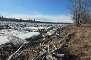
Juneau probably won’t be breaking the snowfall record for January despite those two massive storms within a 12-day period, due to a deluge of rain and record-high temperatures that have dissolved multiple feet of accumulated snow into mere traces in some areas, officials said Monday.
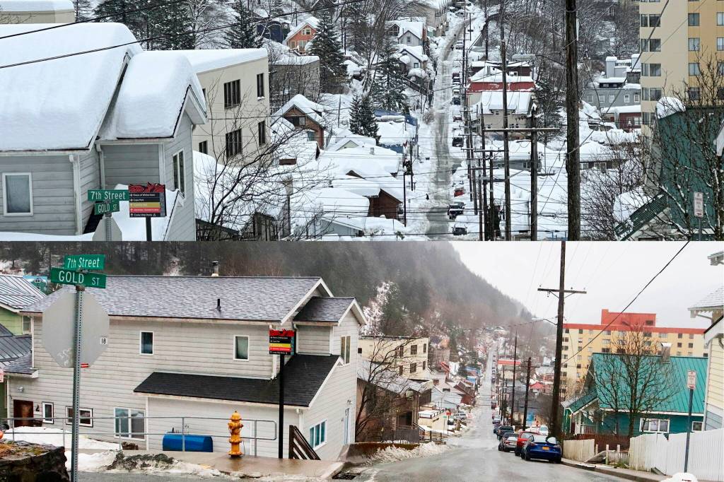
The snowpack at Juneau International Airport reached a peak of 36 inches last Wednesday, said Rick Fritsch, a meteorologist with the National Weather Service Juneau station. As of 9 a.m. Monday “the airport is down to a trace.”
Similarly, the weather station had a maximum snowpack of 40 inches last Wednesday, is also seeing the accumulation vanishing rapidly.
“At three o’clock in the morning we still had 17 inches and nine o’clock in the morning we’re down to 11 inches,” Fritsch said.
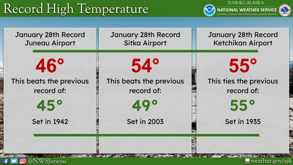
The rapid snowmelt is due to rain that started Friday and intensified during the weekend, with more rain forecast throughout this week. Also, the high temperature of 46 degrees at the airport on Sunday broke the previous record of 45 degrees set in 1945.
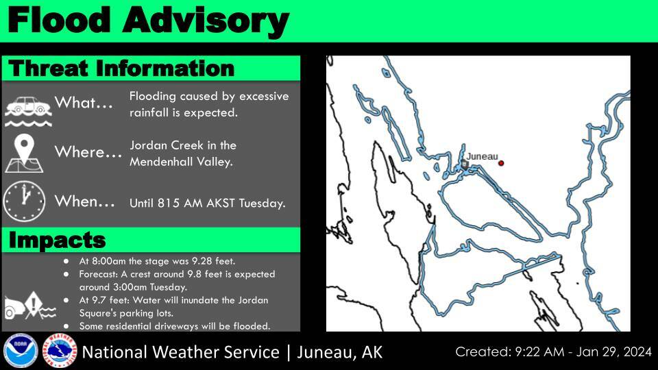
Instead of the winter storm advisories during the blizzards that dumped nearly six feet of snow on some parts of Juneau between Jan. 13-24, high wind warnings were issued during the weekend and a flood advisory is in effect for the Jordan Creek area until 8:15 a.m. Juneau, according to NWS Juneau’s website.
The forecast calls for rain possibly mixed with snow through Thursday, with a chance of snow after that at least through Sunday. High temperatures are expected to drop from the mid-40s on Monday to around or just below 40 on Wednesday, but while there is a possibility of snow it would need to be significant to set a record for the month.
The airport has exactly 70 inches of snow as of midday Monday, compared to an average of 22 inches of snow on this date, Fritsch said. The record for January is 75.2 inches in 2009.
“So real close,” he said. “Close enough for me. I’ve had enough fun shoveling snow this month.”
The rain prompted warnings late last week from city and state officials about the weight of waterlogged snow posing a risk to structures and boats, as well as a high avalanche risk. An avalanche advisory issued by the city Monday morning states the risk will remain high during the day, but is expected to diminish afterward.
“We have the highest temperatures we have seen in the mountains for some time this morning,” the forecast notes. “We also picked up over 1.6” of rain on Douglas and over 2.4” of rain on Mt Roberts while losing 4” of snow at the top of the tram and losing 9” of snow at Powder Patch at Eaglecrest. This is rapidly tearing down and changing the snowpack…Please also be aware that with all this rain, warming and winds, landslide and mass wasting event danger is also considerable today with events possible.”
While more than an inch of additional precipitation is forecast Monday, “today’s storm should find any weakness left in the snowpack,” the advisory notes.
“Today will be the peak of activity before things start to settle back down on Tuesday and Wednesday which will bring a decreasing trend to avalanche danger. The snowpack on the lower mountains is now draining well and yet full depth drainage has not been confirmed at upper elevations in the region where the snowpack is deeper. Once we see full depth percolation, which may have now already occurred, avalanche activity will slow greatly.”
A severe wind warning for some areas in Southeast Alaska was issued Monday by the state Department of Transportation and Public Facilities, which also reported avalanches and other hazards.
“Sitka has a temporary detour in place on Halibut Point Road for an alder tree that snapped and created a hazard above the roadway,” the warning notes. “Petersburg had a hefty spruce tree fall across mile 30 of Mitkof Highway. Wrangell had a small slide near milepost 6 on Zimovia Hwy. And Haines had a slide on Lutak Hwy near milepost 5.”
Winds at Eaglecrest Ski Area peaked at 105 miles per hour on Monday morning, Fritsch said.
The ski area also saw much of its accumulated snowpack dissolve due to rain on the mountain, although a solid base of snow remains, said General Manager Dave Scanlan. He said the upper part of the mountain was closed during the highest wind periods, but the hope is colder weather and better conditions will return by the time the mountain is scheduled to reopen again for its regular season days between Wednesday and Sunday.
“We have a lot more snow than everywhere in town, so we won’t really know until we get back there Wednesday morning,” he said. “This is our weekend. So we’ve got another nasty day of weather. We’re hoping that by midday (Tuesday) we’re going to see a transition back to snow on the mountains. Some of the forecasts are showing as much as another 17 inches of snow falling on the mountain by Friday.”
Scanlan said the storm ended up being a peak period for people able to make it to the ski area — noting Fish Creek Road is plowed by a private operator to help ensure accessibility — with full parking lots and up to two feet of powder at times.
“It was quite busy. Everybody loves getting snowstorms,” he said. “But we really stayed on top of it as best as we could.”
• Contact Mark Sabbatini at mark.sabbatini@juneauempire.com or (907) 957-2306.