Assembly OKs new avalanche and landslide maps, with strong disclaimer for latter
Published 9:30 pm Sunday, December 10, 2023


This story has been updated to correct a quote durng public testimony by Shawn Eisele.
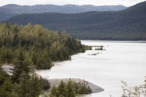
A controversial ordinance updating maps for avalanche and landslide zones was approved by the Juneau Assembly on Monday night after numerous residents concerned about their property values expressed opposition, but with an amendment adding a lengthy disclaimer about the validity of the landslide maps.
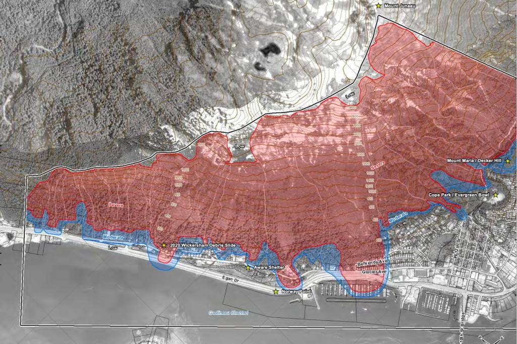
The ordinance states only moderate and severe avalanche zones will be subject to regulation, while locations in landslide zones will merely be mapped with the information provided to property owners and the public. It also repeals landslide and avalanche maps from 1987, and bases the new rules on maps drafted in 2022 that increase the number of properties in high/severe landslide zones to 374 instead of the current 173, including 217 properties not included in the 1987 severe zone.
[Assembly to consider new hazard zone proposal to regulate avalanche areas, notify landslide risks]
The disclaimer, introduced by Assembly member Greg Smith and then approved after a slightly modified version was proposed by Assembly member Alicia Hughes-Skandijs, states the following language “should appear on or be associated with” the 2022 landslide maps:
“The City and Borough of Juneau did not adopt these landslide hazard assessment maps,” the disclaimer states, referring to the fact the maps are not being used for regulatory purposes. “The landslide hazard assessments maps do not consider any human-made structures or mitigating measures. The landslide hazard assessment maps do not provide an indication of risk as would be necessary to determine whether landslide hazards actually pose a threat to specific properties. A more detailed site-specific investigation and evaluation would be required to determine risk to and appropriate mitigations for specific properties.”
The new maps will be posted on the CBJ’s Community Development Department website, and impacted property owners notified annually, but “only properties located in mapped moderate and severe avalanche areas will be regulated,” according to a summary by City Manager Katie Koester.
Numerous people testifying at Monday’s meeting asked for a strongly-worded disclaimer, with some requesting it include language the maps aren’t valid for property insurance, loan or assessment purposes.
Shawn Eisele, among the downtown residents in a hazard zone on the new maps, said that while Southeast Alaska is vulnerable to dangers such as avalanches the proper approach is to take “thoughtful steps” to keep the community safe, such as improved slope and rainfall monitoring and analysis.
“In my case, and many others, those next steps would be considering the mitigating measures and structures above their property,” he said. “But there are lots of reasons the zones are not accurate and there is currently no way for us to do the next steps or be exempted from these maps that will now be sitting publicly on the digital shelf.”
City Attorney Robert Palmer told Assembly members it’s questionable if disclaimer language referring to financial institutions such as insurers and banks would have a meaningful impact in such situations.
“That is a really tricky question because it’s almost a chicken-and-the-egg concept as to did the landslide hazards come first or did the maps come first,” he said. The report by the company drafting the new maps “identifies that they’re only mapping current conditions and what they expect to be the hazards for the current conditions. So even without the maps the finance industry, the assessing industry, the lending industries could make their own determinations that there’s risks and hazards. So it’s really tough to know right now.”
The amendment and the ordinance were both unanimously approved by the Assembly, despite some reservations expressed by some members during a lengthy discussion. Hughes-Skandijs noted the Assembly, city officials and residents have spent years debating an update of the risk maps, and “I think that’s brought to the forefront of some of the dangers of messing with his ordinances and regulating in general, and how it affects homeowners and our residents.”
Also, Hughes-Skandijs said, the landslide in Wrangell on Nov. 20, which killed five people with one still officially missing, is among the reminders of the natural hazards facing the region.
“As climate change continues, and it does get getting warmer and wetter, that is a real danger,” she said. “And so I just want us to be clear-eyed as we go into this that there’s not a lot of really safe places to live in Juneau and this is still where we’ve chosen to live.”
Eisele, in an interview after the vote, said the disclaimer added to the ordinance passed by the Assembly largely addresses his concerns.
“It’s not exactly what everybody wanted, but nothing is and it’s a step in the right direction,” he said. “I think this is a really hard issue with a lot of things that impact people in a lot of different ways.”
The ordinance takes effect 30 days after its passage by the Assembly. However, consideration of its provisions is not over yet.
An additional related measure was introduced following the vote by Assembly member Michelle Bonnet Hale, stating property tax notices sent to property owners be accompanied by a statement to the effect of “if you live on a slope you may get risks or landslides, or if you live on the water you may get risks for flooding or erosion.”
“So it’s a general statement letting people know that we have risks here,” she said, adding the notice is intended to replace the notice sent only to people affected by the landslide zone maps.
Assembly members voted 6-3 to refer the proposed measure to the Committee of the Whole for further consideration after city staff drafts formal language. Assembly member Christine Woll was among those opposing the proposal, stating she considers it too broad.
“I much prefer that we notify individuals that we know are in dangerous areas based on the best available information we have,” she said.
• Contact Mark Sabbatini at mark.sabbatini@juneauempire.com or (907) 957-2306.