Assembly to consider new hazard zone proposal to regulate avalanche areas, notify landslide risks
Published 9:30 pm Thursday, November 9, 2023

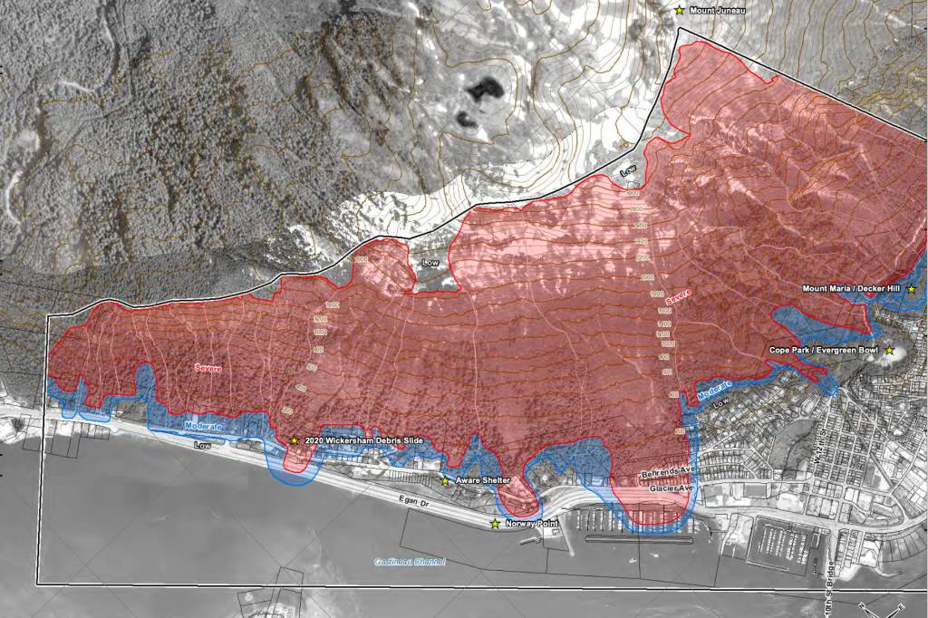


The issue of areas at risk of avalanches and landslides is back before the Juneau Assembly, but with a proposed change so that only properties in moderate and severe avalanche zones will be regulated. Locations in landslide zones will be mapped, with the information provided to property owners and the public.
A revised ordinance is scheduled to get initial consideration during the Assembly’s meeting at 7 p.m. Monday, after members meeting as the Committee of the Whole approved advancing the measure at its meeting earlier this week. The proposal would be subject to public testimony at a subsequent meeting, with the next regular meeting scheduled Dec. 11, before it could be adopted.
[Assembly sends hazard maps back to committee following public opposition]
Also scheduled for possible final approval — and thus public testimony — during Monday’s Assembly meeting are:
• Authorizing a cold weather emergency shelter now operating in a city-owned warehouse in Thane.
• Allocating $300,000 for the first phase of construction of an off-road vehicle riding park.
• Allocating $28,000 as a five-fold increase in city funding for monitoring of Suicide Basin following recording flooding in August.
The issue of maps designating avalanche and hazard zones has been ongoing for years, following the commission of new maps by the city in 2018 that were paid for by a grant from the Federal Emergency Management Agency, and subsequent maps drafted in 2022. The existing maps adopted by the city in 1987 are based on those created during the 1970s, and the newer maps would increase the number of properties in high/severe landslide zones to 374 instead of the current 173, including 217 properties not included in the 1987 severe zone.
Many property owners in the affected areas have expressed concern about adopting the maps, and that a new hazard designation could affect property values, resale options and insurance costs. The full Assembly most recently heard the matter during a Sept. 11 meeting when additional public testimony was heard, after which members voted to send the matter back to the Committee of the Whole for further consideration.
The proposed ordinance now before the Assembly is based on city Avalanche Hazard Designation Mapping from April 27, 2022, according to City Manager Katie Koester. If approved, landslide and avalanche maps would be posted on the CBJ’s Community Development Department website, and impacted property owners notified annually, but “only properties located in mapped moderate and severe avalanche areas will be regulated.”
“From a logistical perspective we took that to mean an annual postcard that would go out to people who lived within 500 feet of the mapped landslide area and a public service announcement,” she told Assembly members during Monday’s meeting.
But whether removing landslide areas from regulation would make any difference was questioned by Assembly member Wade Bryson, who noted the map designations for avalanches and landslides largely overlap.
“I read this as if nothing has changed for the residents of Juneau,” he said. “They still will be impacted if they want to live or build or develop or buy in this shaded area because it’s still a hazard zone. We haven’t eliminated or made any improvements.”
City Attorney Robert Palmer acknowledged the avalanche zones are retained in the proposed ordinance, “although they’re a little different — some properties are out, some are in” compared to previously considered versions. The regulations, he said, would differ depending on the type of development occurring.
“If this ordinance is adopted it still generally allows the (community development) director to permit single-family homes or a dwelling unit,” he said, noting there are also conditions that would apply in certain situations. “Anything more than that would require a Planning Commission process.”
The issue of “how people can get lending and insurance is a separate question,” Palmer said.
“Could this impact that? Yes,” he said. “But the question I think may be one of the chicken and the egg. Are we regulating because there’s hazards? Or are we creating the hazard?”
A motion to repeal the current landslide and avalanche maps, along with the related land-use code, and regulate moderate- and severe-level avalanche zones only was made during a Committee of the Whole meeting in August. But Assembly member Greg Smith, during Monday’s meeting, asked if the proposed ordinance to publish the landslide maps would essentially have the same limiting impact as regulations.
“A big, big thing we had heard during public testimony is can you unring the bell now?” he said. “Have we heard from anyone that this language would do that? And essentially by just having the maps out in the world, whether or not we adopt them, have we complicated or prevented transactions of real estate in landslide-designated hazard zones?”
Jill Maclean, the city’s community development director, said she hasn’t received an “on-the-record” answer to that question from insurance agents and similar stakeholders.
“All these properties are so different, site by site,” she said. “So for any one of them to step up and try to give a blanket statement on whether or not this solves all the problems or doesn’t, I can understand why they wouldn’t want to come forward in such a public fashion.”
Assembly members voted 8-1 to send the proposed ordinance from the Committee of the Whole to the full Assembly again during its upcoming meeting. Smith, while noting issues still need examination such as potential costs and “some sense of unfairness” among some people, said “overall it’s moving us in the right direction.”
The dissenting vote was cast by Bryson, who argued for simply repealing the 1987 maps now in use.
If we repeal the 1987 maps we are unringing the bell and we are allowing this community to develop the way they want to people can develop what they want to on their lands,” he said. “And it’s not like we’re saying you’re carte blanche and you can go build whatever you want because every single person that wants to build in an area that may potentially have an avalanche or a landslide still has to get it permitted through CDD. They have to come up with enough financial resources. If they’re getting a loan, they’re going to have to have bank approval.”
Other issues up for consideration
• The cold weather emergency shelter is another controversial issue scheduled for consideration on Monday, following months of disputes about its location and operator.
The shelter was operated by Resurrection Lutheran Church during the previous two years, but the congregation voted in June and again in September not to negotiate with the city for a contract this year. By the time a third vote was conducted in early October narrowly approving such negotiations, city officials were already considering alternatives and subsequently signed an agreement to have St. Vincent de Paul operate the exiting shelter about a mile south of the Goldbelt Tram that opened Oct. 20.
The opening occurred despite the lack of Assembly authorization, with city and St. Vincent de Paul officials saying subfreezing temperatures justified the decision. The ordinance before the Assembly “exempts the use of 1325 Eastaugh Way as the Cold Weather Emergency Shelter from all requirements and prohibitions of the land use code for five years.”
A petition challenging the new shelter has been circulated by leaders at Resurrection Lutheran Church, who argue the location well away from downtown and limited facilities make it unsuitable for people in emergency situations seeking shelter, as well as questioning what they call a lack of proper public process.
• The $300,000 for the construction of the first phase of Juneau’s first ORV riding park — located at 35 Mile Glacier Highway in a former logging area in the 1950s-1960s — would construct five miles of trails through a 175-acre site contained within a larger 565-acre tract owned by the CBJ.
“It will likely take multiple years to build this phase, and subsequent phases will be mapped, planned, and permitted in the field,” a summary of the proposed ordinance notes.
• The additional funding for Suicide Basin monitoring is among numerous proposed remediation and prevention efforts by the city following the Aug. 5 flooding of the Mendenhall River that damaged or destroyed dozens of residences. It would boost the current $7,000 annual allocation to the U.S. Geological Survey to a total of $35,000 to allow for additional cameras, sensors and other data collection.
• Contact Mark Sabbatini at mark.sabbatini@juneauempire.com or (907) 957-2306.