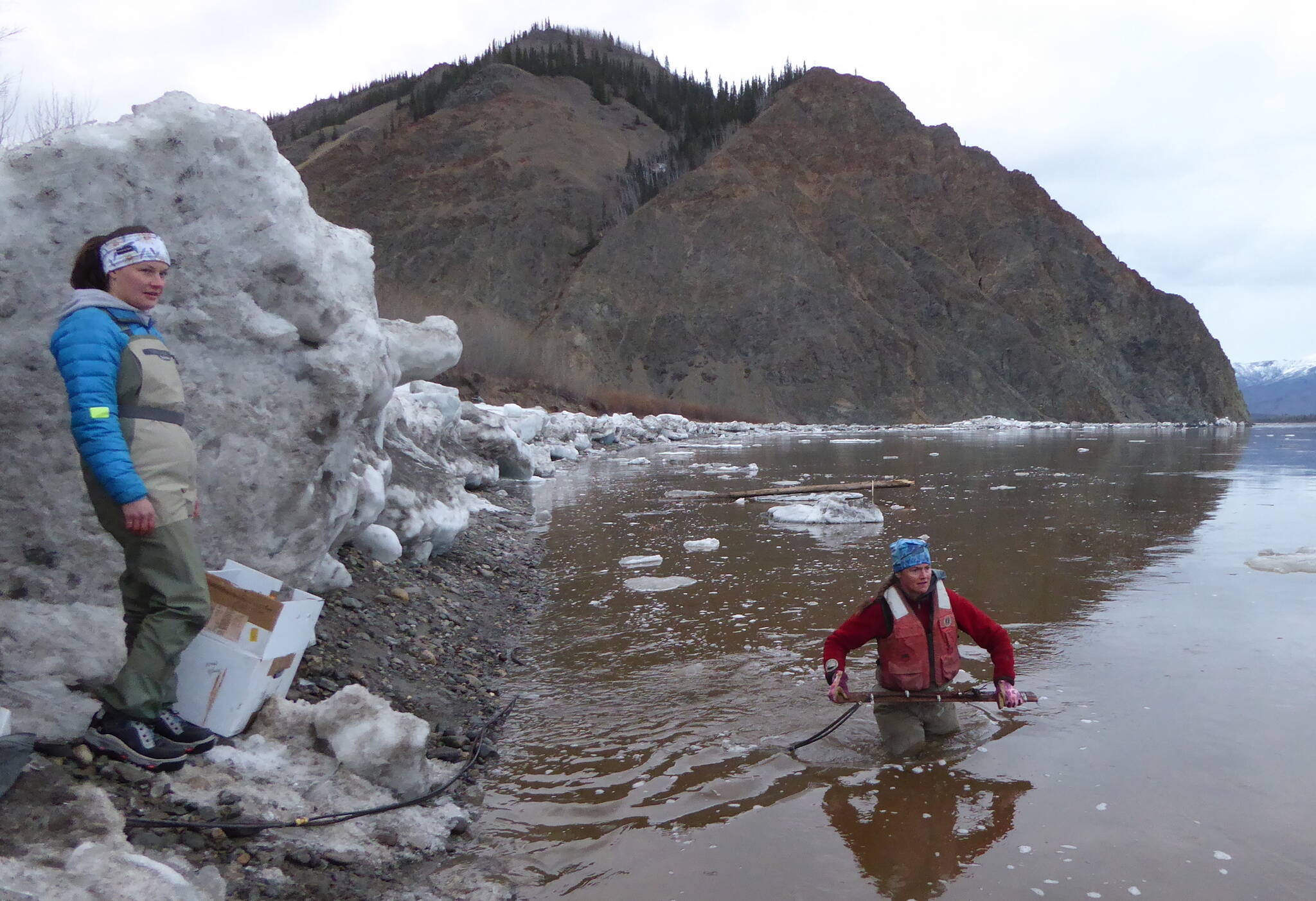
Heather Best (in water), a USGS hydrologist, prepares to toss a road-grader blade with a river-measuring device attached into the Yukon River near Eagle, Alaska. USGS hydrologic technician Liz Richards watches for icebergs. (Courtesy Photo / Ned Rozell)

Heather Best (in water), a USGS hydrologist, prepares to toss a road-grader blade with a river-measuring device attached into the Yukon River near Eagle, Alaska. USGS hydrologic technician Liz Richards watches for icebergs. (Courtesy Photo / Ned Rozell)

Alaska Science Forum: Wading into the icy Yukon River for science

EAGLE, ALASKA — Snow geese flew in a ragged V overhead, rasping as they looked down upon Alaska’s bumpy face for the first time in 2022.

Nine hundred feet below, the Yukon River flowed by quietly, except for the dull thuds of icebergs skidding along the river bottom near the shore.

Sensing a break in the ice traffic, U.S. Geological Survey hydrologist Heather Best — wearing chest waders with a hole she would soon discover — stepped into the river. In both hands, she held a 3-foot portion of grader blade. Running along the blade was river-measuring tube secured by hose clamps.

That hunk of steel held the business end of a device Best and others use to measure the flow of the Yukon River at Eagle, a town of about 110 people just downstream of the Canada border.

A few days earlier, ice formed by the cold air of winter had knocked the river-measuring instrument offline. During river breakup at Eagle, rising meltwater lifted a sheet of ice that had been in place most of the winter.

Brown water then ferried immense shards of ice downstream at about 5 miles per hour. Some of it crashed into the bank on an outer river bend just down from Eagle. Those icebergs ripped the river-measuring hose from the shore where it entered the river, shearing it in a few places.

Best and USGS hydrologic technician Liz Richards had driven from their office in Fairbanks to see if they could fix the river-measuring instrument. They stopped at other waterways during the 10-hour journey, to see if stream information being sent to the internet was accurate and fix things that got dinged up as winter’s ice turned to water.

On the shoreline of the Yukon River, after an hour’s work that included scrambling over ice chunks large as pickups, Best and Richards had spliced the measuring tube where the ice severed it. They reattached it to the grader blade. Then came the trickiest part — the redeployment of the tube beneath the surface of the Yukon.

Trying to keep her time immersed in ice water to a minimum, Best sidestepped out on rocks she couldn’t see beneath the surface. Once the river reached the belt around her waist, she stopped.

Best heaved the grader blade as far as she could into the water. She then retreated toward the shore.

“Nice work,” Richards said from a sliver of gravel shoreline in front of a pile of ice.

“I hope it’s deep enough,” Best said.

The submerged end of a hose would release bubbles of nitrogen into the river in a complicated, somewhat magical system that converts sensed water pressure at the opening of the underwater hose to river depth.

Best said the underwater end had to be deep enough to stay submerged in the coming weeks. If not, she or someone else would have to come back in midsummer, after the river level dropped, to throw the grader blade a little deeper.

“We need it to be at least 4 feet deep,” she said.

Carrying bits of broken hose and a cardboard box of equipment and tools, Best and Richards toed into a steep slope, reaching a small cedar cabin on a grassy bench near the National Park Service field station in Eagle.

Inside the structure were the plastic pipes, glass bulbs and nitrogen tanks that make up the “Conoflow gas-purge system,” a staple of USGS river-and-stream measuring sites around the country.

After a little fiddling with the system, Best had good news.

“It looks like it’s in 5 feet of water,” she said.

“Yay,” Richards said.

The women then tidied the little shelter. Best shut the door and padlocked it, and the pair walked to their car, which would take them a few hundred feet to their room with a view of the big river. They would drive out of Eagle on the Taylor Highway the next day, doing a bit more fieldwork on the way home.

As for the town of Eagle, the geese kept passing over in mixed flocks, songbirds flooded the local aspens and people mentioned seeing the first returning swallows.

The river, almost free of ice but soon to swell with meltwater from winter’s snow still in the mountains of Canada and Alaska, once again had its level visible to people far from Eagle, on the USGS website at https://on.doi.gov/3lkbjTL.

• Since the late 1970s, the University of Alaska Fairbanks’ Geophysical Institute has provided this column free in cooperation with the UAF research community. Ned Rozell is a science writer for the Geophysical Institute.
Liz Richards, a hydrologic technician for USGS, pulls in an anchor attached to a river-level measuring device from the Yukon River just downstream of Eagle, Alaska. (Courtesy Photo / Ned Rozell)

Liz Richards, a hydrologic technician for USGS, pulls in an anchor attached to a river-level measuring device from the Yukon River just downstream of Eagle, Alaska. (Courtesy Photo / Ned Rozell)

Liz Richards, left, a hydrologic technician for USGS, and Heather Best, a USGS hydrologist, repair a river-level measuring device that ice damaged during Yukon River breakup a few days earlier. (Courtesy Photo / Ned Rozell)

Liz Richards, left, a hydrologic technician for USGS, and Heather Best, a USGS hydrologist, repair a river-level measuring device that ice damaged during Yukon River breakup a few days earlier. (Courtesy Photo / Ned Rozell)

More in News

Jasmine Chavez, a crew member aboard the Quantum of the Seas cruise ship, waves to her family during a cell phone conversation after disembarking from the ship at Marine Park on May 10. (Mark Sabbatini / Juneau Empire file photo)
Ships in port for the week of July 20

Here’s what to expect this week.

A young girl plays on the Sheep Creek delta near suction dredges while a cruise ship passes the Gastineau Channel on July 20. (Jasz Garrett / Juneau Empire)
Juneau was built on mining. Can recreational mining at Sheep Creek continue?

Neighborhood concerns about shoreline damage, vegetation regrowth and marine life spur investigation.

Left: Michael Orelove points out to his grandniece, Violet, items inside the 1994 Juneau Time Capsule at the Hurff Ackerman Saunders Federal Building on Friday, Aug. 9, 2019. Right: Five years later, Jonathon Turlove, Michael’s son, does the same with Violet. (Credits: Michael Penn/Juneau Empire file photo; Jasz Garrett/Juneau Empire)
Family of Michael Orelove reunites to celebrate the 30th anniversary of the Juneau Time Capsule

“It’s not just a gift to the future, but to everybody now.”

Sam Wright, an experienced Haines pilot, is among three people that were aboard a plane missing since Saturday, July 20, 2024. (Photo courtesy of Annette Smith)
Community mourns pilots aboard flight from Juneau to Yakutat lost in the Fairweather mountains

Two of three people aboard small plane that disappeared last Saturday were experienced pilots.

A section of the upper Yukon River flowing through the Yukon-Charley Rivers National Preserve is seen on Sept. 10, 2012. The river flows through Alaska into Canada. (National Park Service photo)
A Canadian gold mine spill raises fears among Alaskans on the Yukon River

Advocates worry it could compound yearslong salmon crisis, more focus needed on transboundary waters.

A skier stands atop a hill at Eaglecrest Ski Area. (City and Borough of Juneau photo)
Two Eaglecrest Ski Area general manager finalists to be interviewed next week

One is a Vermont ski school manager, the other a former Eaglecrest official now in Washington

Anchorage musician Quinn Christopherson sings to the crowd during a performance as part of the final night of the Áak’w Rock music festival at Centennial Hall on Sept. 23, 2023. He is the featured musician at this year’s Climate Fair for a Cool Planet on Saturday. (Clarise Larson / Juneau Empire file photo)
Climate Fair for a Cool Planet expands at Earth’s hottest moment

Annual music and stage play gathering Saturday comes five days after record-high global temperature.

The Silverbow Inn on Second Street with attached restaurant “In Bocca Al Lupo” in the background. The restaurant name refers to an Italian phrase wishing good fortune and translates as “In the mouth of the wolf.” (Laurie Craig / Juneau Empire)
Rooted in Community: From bread to bagels to Bocca, the Messerschmidt 1914 building feeds Juneau

Originally the San Francisco Bakery, now the Silverbow Inn and home to town’s most-acclaimed eatery.

Waters of Anchorage’s Lake Hood and, beyond it, Lake Spenard are seen on Wednesday behind a parked seaplane. The connected lakes, located at the Ted Stevens Anchorage International Airport, comprise a busy seaplane center. A study by Alaska Community Action on Toxics published last year found that the two lakes had, by far, the highest levels of PFAS contamination of several Anchorage- and Fairbanks-area waterways the organization tested. Under a bill that became law this week, PFAS-containing firefighting foams that used to be common at airports will no longer be allowed in Alaska. (Yereth Rosen/Alaska Beacon)
Bill by Sen. Jesse Kiehl mandating end to use of PFAS-containing firefighting foams becomes law

Law takes effect without governor’s signature, requires switch to PFAS-free foams by Jan. 1

Most Read