An extended advisory forecasting up to eight more inches of snow by 9 a.m. Sunday, in addition to about four inches of snow that fell between Friday evening and Saturday afternoon, is issued by the National Weather Service Juneau at 12:50 p.m. Saturday. (National Weather Service Juneau)

An extended advisory forecasting up to eight more inches of snow by 9 a.m. Sunday, in addition to about four inches of snow that fell between Friday evening and Saturday afternoon, is issued by the National Weather Service Juneau at 12:50 p.m. Saturday. (National Weather Service Juneau)

Advisory for latest weekend storm extended, with more than a foot of snow possible by 9 a.m. Sunday

Storm that began Friday night continues pattern that led to record snowfall in January.

Here we go again.

The end of January and its record 76.8 inches of snow is giving way to a February where more than a foot of snow may fall during the first weekend of the month, according to the National Weather Service Juneau.

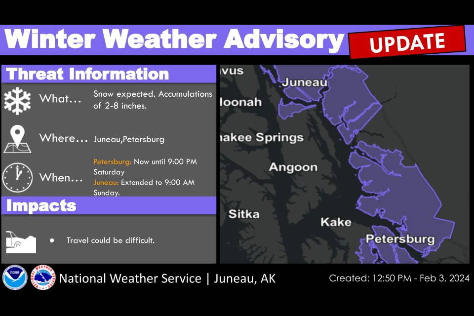
Between four and five inches of snow fell in parts of town between Friday evening and early Saturday afternoon, and an advisory issued by the weather service at about 12:50 p.m. Saturday forecasts up to eight more inches are possible by 9 a.m. Sunday.

There was also heavy snow on the first day of February resulting from a storm that dumped about 13 inches on the city during a 24-hour period between the latter part of Wednesday, Jan. 31 — with the 6.8 inches of snow on that date allowing Juneau to set a new record — and Thursday.

As with some of the January storms, the advisory for the current storm is now both longer and for a greater amount of snow than originally forecast.

Edward Liske, a lead meteorologist for NWS Juneau, said the original winter weather advisory was until 6 p.m. Saturday. But that was extended until midnight and then again until 9 a.m. Sunday because “the deep showers of snow — more or less that’s what we’re seeing right now coming in from the gulf — is probably going to stick around through tomorrow morning.”

“We may start seeing a mix toward rain toward midday tomorrow,” he said. “It might take a little longer, depending on how strong the warm air push from the south is, because we’ve had times this season already — in fact in the last month — where the cold’s just stuck around and it stayed snow for much longer. But the general idea right now is that it’s probably going to start mixing with snow sometime tomorrow afternoon.”

While two major storms in January that totaled nearly 70 inches of snow in some areas were followed by multiple days of heavy rainfall and record-high temperatures that dissolved virtually all the accumulation in town, that isn’t likely to happen during the coming days. The extended NWS Juneau forecast through next week is for a continuing chance of snow most days, with highs in the mid-30s and lows in the mid-20s.

The 76.8 inches of snow at Juneau International Airport in January topped the previous record for the month of 75.2 inches set in 2009. But Liske said it fell well short of the all-time monthly record of 86.3 inches set in February of 1965.

If Juneau gets close to that amount near the end of the month, it’s worth noting this is a leap year and thus there is an extra day for a record (arguably with an asterisk) to be set.

• Contact Mark Sabbatini at mark.sabbatini@juneauempire.com or (907) 957-2306.

More in News

The northern lights are seen from the North Douglas launch ramp late Monday, Jan. 19. A magnetic storm caused unusually bright northern lights Monday evening and into Tuesday morning. (Chloe Anderson/Juneau Empire)
Rare geomagnetic storm causes powerful aurora display in Juneau

The northern lights were on full display Monday evening.

The Alaska State Capitol building stands on Tuesday, Jan. 20, 2025. (Mari Kanagy/Juneau Empire)
Rep. Story introduces bill aiming to stabilize education funding

House Bill 261 would change how schools rely on student counts.

Weekly events guide: Juneau community calendar for Feb. 9 – 15
Juneau Community Calendar

Weekly events guide: Feb. 9 – 15

teaser
Juneau activists ask Murkowski to take action against ICE

A small group of protesters attended a rally and discussion on Wednesday.

A female brown bear and her cub are pictured near Pack Creek on Admiralty Island on July 19, 2024. (Chloe Anderson for the Juneau Empire)
Pack Creek permits for bear viewing area available now

Visitors are welcome from April 1 to Sept. 30.

Cars pass down Egan Drive near the Fred Meyer intersection Thursday morning. (Clarise Larson / Juneau Empire file photo)
Safety changes planned for Fred Meyer intersection

DOTPF meeting set for Feb. 18 changes to Egan Drive and Yandukin intersection.

Herbert River and Herbert Glacier are pictured on Nov. 16, 2025. (Mari Kanagy / Juneau Empire)
Forest Service drops Herbert Glacier cabin plans, proposes trail reroute and scenic overlook instead

The Tongass National Forest has proposed shelving long-discussed plans to build a… Continue reading

A tsunami is not expected after a 4.4-magnitude earthquake northwest of Anchorage Wednesday, Feb. 4, 2026. (U.S. Geological Survey)
No tsunami expected after 4.4-magnitude earthquake in Alaska

U.S. Geological Survey says 179 people reported feeling the earthquake.

ORCA Adaptive Snowsports Program staff member Izzy Barnwell shows a man how to use the bi-ski. (SAIL courtesy photo)
Adaptive snow sports demo slides to Eaglecrest

Southeast Alaska Independent Living will be hosting Learn to Adapt Day on Feb. 21.

Most Read