U.S. preparing to claim new ocean territory off Arctic Alaska and in central Bering Sea
Published 9:30 pm Wednesday, December 27, 2023

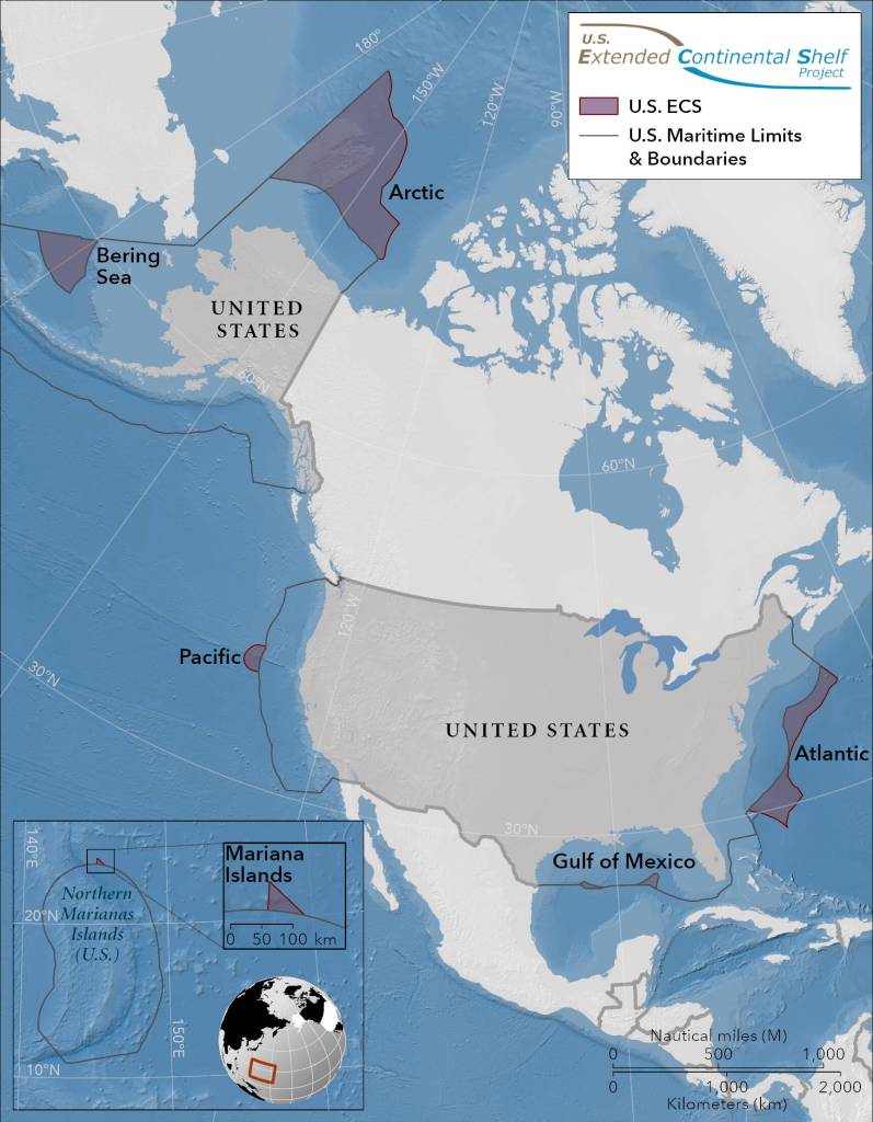


United States ocean territory could expand by an area more than twice the size of California, with most of that in ocean areas off Alaska, under a claim being prepared by the federal government.
The U.S. State Department this month announced results of a two-decade program to map the extended continental shelf areas beyond the nation’s 200-mile exclusive economic zone. Much of the focus was on the Arctic Ocean, where bathymetric and geologic surveys by federal agencies produced the first detailed maps of a complex seafloor with a series of canyons, ridges and deep-sea plateaus.
In all, the mapping reveals that the U.S. has rights to an additional 987,700 square kilometers, an area about twice the size of California, according to the State Department. Of that, more than half – 520,400 square kilometers – is in the Arctic Ocean beyond the 200-mile exclusive economic zone off Alaska’s North Slope. Another 176,330 square kilometers is contained in a triangular section in the Bering Sea that abuts the U.S.-Russia maritime border. There are also claims in the works to territory off the Atlantic and Pacific coasts, the Gulf of Mexico and the Mariana Islands area.
The decades-long project to map the extended continental shelf involved the National Oceanic and Atmospheric Administration, the U.S. Geological Survey and other agencies and, within the Arctic, numerous research voyages by the U.S. Coast Guard icebreaker Healy. It sets up a formal claim to be made to the international community, the State Department said.
“The continental shelf is the extension of a country’s land territory under the sea. Like other countries, the United States has rights under international law to conserve and manage the resources and vital habitats on and under its ECS,” the State Department said in its Dec. 19 announcement.
Under international law, countries have the right to claim sovereignty over areas of the ocean that lie beyond the 200-mile limit, as long as those areas are physically connected to underwater shelves that extend from continental masses. Sovereignty includes control over resource development.
But for the U.S., there is a catch: The U.S. Senate has not ratified the 1982 United Nations Convention on the Law of the Sea, the treaty under which such claims are adjudicated.
Ratification requires a vote of two-thirds of the U.S. Senate, and key Republicans, starting with then-President Ronald Reagan, have rejected the idea for decades.
For U.S. Sen. Lisa Murkowski, R-Alaska, the Arctic Ocean mapping adds some urgency to her latest effort to win ratification.
A bill she introduced in November, her third such attempt at passage, might be successful now that there are potentially tangible benefits to ratifying the treaty, she said at a Dec. 22 news conference.
“I’m really optimistic that things are different,” she said. Resistance has always been within her party, she noted. “But as I have talked with different colleagues, there has been a genuine interest in knowing and learning and understanding more.”
She noted that her bill has a Republican cosponsor, Sen. Bill Cassidy, R-Louisiana.
Murkowski said her understanding is that the U.S., without ratification, has the right to make claims, but it does not have the right to mount challenges. Without ratification, she said, “we’re limited in terms of our ability to not only defend our claim, but then to push back on others as well.”
Being part of the Law of the Sea treaty would help the U.S. assert more control in not only the Arctic, as climate warming opens up the waters to more activity, but in disputed areas like the South China Sea, Murkowski said.
Former Lt. Gov Mead Treadwell, who chaired the U.S. Arctic Research Commission from 2006 to 2010, has also argued in favor of ratification.
Without it, he said, the U.S. claim could run into some trouble. “It’s a problem if somebody challenges us who believes they’re got other rights to the same land,” he said.
In fact, the extended continental shelf mapped out by the U.S. in the Arctic does overlap a bit with the extended continental shelf claimed by Canada, a matter that the State Department said will have to be settled sometime in the future.
Nonetheless, the territory staked out by the national mapping project, at least in the Arctic and Bering areas off Alaska, appears to be within U.S. rights, Treadwell said. By skirting around well-recognized maritime borders, they largely avoid areas of contention, he said.
In contrast, there are some significant conflicts in claims made by other Arctic nations. Russia and Canada, which years ago ratified the treaty, are pushing competing and overlapping Arctic Ocean claims, for example. Russian claims extend beyond the North Pole, while Canada’s claims to 1.2 million square kilometers of Arctic Ocean seabed and subsoil, also encompass the North Pole.
The newly mapped U.S. Arctic territory does not extend that far north. The most northern point is 680 nautical miles beyond the current 200-mile exclusive economic zone limit.
Within the Arctic territory that the U.S. is intending to claim as its extended continental shelf is a topographical feature called the Chukchi Borderland, located 600 miles north of the Bering Strait. There, underwater ridges and plateaus rise from the seafloor at a point where warmer, saltier water flowing in from the Atlantic meets the colder, fresher water flowing from the Pacific.
The Chukchi Borderland is clearly an extension of land in Arctic Alaska, according to the State Department’s documents.
“Extensive geophysical data and interpretation show that the Chukchi Borderland and the northern Chukchi elevation share a fundamental morphologic, structural, geochemical, geophysical, and tectonic connection with the Chukchi Shelf and northern Alaska,” said the department’s executive summary.
Treadwell said the U.S. extended continental shelf assertion could reap some valuable economic and regulatory benefits. He made those arguments in an essay published on Dec. 19 by the Washington, D.C.- based Wilson Center, where he serves as a Polar Institute advisory committee member.
Aside from potential resource extraction, the extended continental shelf – now that it is better understood – could be used to properly place long-distance fiber-optic connections, for example, he said. And if U.S. sovereignty in the area is affirmed, the U.S. will have the right to regulate and inspect other nations’ research vessels working in the area, an activity on the rise as China, Korea and Japan expand their icebreaker fleets, he said.
“Once we have it, we’ll figure out what we do with it,” he said.
• Yereth Rosen came to Alaska in 1987 to work for the Anchorage Times. She has reported for Reuters, for the Alaska Dispatch News, for Arctic Today and for other organizations. She covers environmental issues, energy, climate change, natural resources, economic and business news, health, science and Arctic concerns. This story originally appeared at alaskabeacon.com. Alaska Beacon, an affiliate of States Newsroom, is an independent, nonpartisan news organization focused on connecting Alaskans to their state government.