Sunny Point route near airport runway gets highest score for second Juneau-Douglas crossing
Published 9:30 pm Sunday, March 10, 2024


A second Juneau-Douglas crossing near southeast end of the runway at Juneau International Airport is the highest-scoring of seven options based on field research and other screening criteria, according to a study presented to city leaders Monday.
However, all seven options received negative “performance against criteria” scores in assessing environmental impacts, disruptions to residential and commercial activity, right-of-way issues, and other factors. Yet the lowest scoring option of all is the “no-build alternative,” even though about 30% of people responding to a survey stated it was their preference.
Furthermore, the proposed crossing southeast of the runway is raising concerns about airport safety and impacts on the Mendenhall Wetlands State Game Refuge, including accusations that officials involved with the study are overlooking or downplaying those concerns.
The findings presented to the City and Borough of Juneau Public Works and Facility Committee are part of a partnership with the state Department of Transportation and Public Facilities to study possible routes for a second crossing that has been publicly debated for four decades. However, with the federal government providing $23.5 million last year for design work local officials say the project may be close to reality.
The hope is to complete a Planning and Environmental Linkages (PEL) study for a preferred route by July, which among other steps is expected to involve further public input including an open house in June, said Steve Noble, project manager for DOWL, hired to conduct the study for the city-state partnership. However, he said the crossing itself is likely still many years and steps in the public process away.
“Once the document is finalized then CBJ and DOT will need to make the determination if they’re going to move forward with the preliminary and (National Environmental Policy Act) work,” he said. “If that does move ahead, we anticipate it to take at least a couple of years, followed by two to three years — at least — for the engineering design and right-of-way acquisition tasks, which would put construction to be at least five years out from today.”
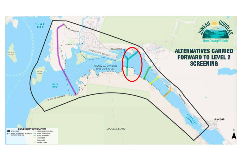
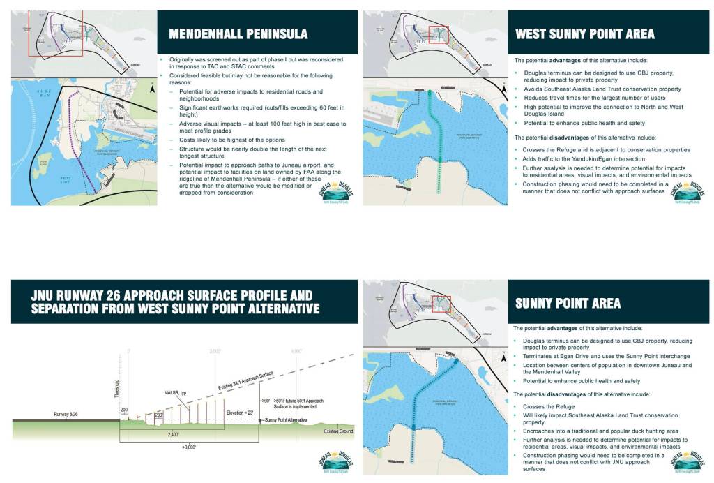
The study evaluates six possible crossing routes between Salmon Creek (about three miles north of the current Douglas Bridge) and Fritz Cove Road on the Mendenhall Peninsula (about 12 miles north). Two are variations of the route southeast of the runway that would cross the Mendenhall Wetlands and connect at Mile Six of North Douglas Highway. The highest-scoring Sunny Point East option connects to Egan Drive at the intersection where the U-Haul building is located, while a third-ranked Sunny Point West option connects closer to the airport near Switzer Village.
All seven options were evaluated using seven criteria that each got a score between plus two and minus two. Sunny Point East’s cumulative score was minus three, while the no-build option finished lowest with minus 18.
“For this alternative the greatest potential impacts quantified are protected lands, neighborhoods that are potentially divided or disrupted, and the need for residential property acquisition,” Renee Whitesell, lead author of the study for DOWL, during Monday’s presentation to the committee.
Specifically, the study states it would impact 0.0006 acres of protected Southeast Alaska Land Trust conservation lands, divide or disrupt two residential neighborhoods, and require acquiring two residential parcels totaling 5.1 acres. However, that list is significantly shorter than the other action alternatives.
Whitesell said the Sunny Point East option was among three with a “relatively high level of support” among public members polled.
By comparison, the Sunny Point West option — while following about two-thirds of the same route as Sunny Point East — has an overall score of minus eight and a much longer list of impacts. Those include 7.2 acres of wetlands, eight anadromous streams, about 25 migratory bird habitats, acres of “impervious surfaces added,” three neighborhoods divided or disrupted, and 48 residential properties within 100 feet of the crossing.
The Sunny Point East option has a projected construction cost of $420 million and annual maintenance cost of $165,000. That and the associated Sunny Point West option projected at $390 million to build are the closest to the $400 million construction cost estimated in the Statewide Transportation Improvement Plan submitted to the federal government on March 1, which is being reviewed and has a March 31 approval deadline after an earlier draft of the state’s plan was rejected due to a multitude of cited flaws.
By far the longest and most expensive option is the Mendenhall Peninsula crossing with an estimated construction cost of $1.7 billion and annual maintenance cost of $365,000. It also has a criteria score of minus 11 due to a wide variety of impacts ranging from disrupting commercial activities to the presence of five nesting bald eagle sites.
The other three action alternatives had projected construction costs between $270 million and $330 million, and maintenance costs between $65,000 and $90,000.
Noble said the costs don’t include right-of-way land acquisition, which for the Mendenhall Peninsula and Salmon Creek options in particular would likely be significant.
The other two crossing alternatives are between Sunny Point East and Salmon Creek options at Twin Lakes and Vanderbilt Hill.
Whitesell said the Twin Lakes and Salmon Creek options scored relatively low in the survey of residents, the Mendenhall Peninsula was moderate and the Vanderbilt option was relatively high.
Concerns about the Sunny Point and Mendenhall Peninsula options have been expressed by the Juneau Airport Board due to their potential impacts on navigation. City Manager Katie Koester, in a March 1 memo to the Assembly, noted a letter expressing those concerns was drafted for Alaska’s congressional delegation, but not sent.
Instead, DOWL and other officials met with the airport board in January as part of the review process, addressing specific issues for each of the three routes of concern to the board. A presentation from that meeting states the key issue for the airport board is it is “not in favor of alternatives that will limit existing or future airport operations or that will conflict with approach surfaces.” The responding “project team commitment” is “any alternative that conflicts with the approach surfaces or the (airport layout plan) will be modified to eliminate conflicts or removed from consideration.”
Those findings were presented during a joint meeting of the Assembly and airport board on March 6. But reassurances the airport board’s concerns will be factored into a recommended route were met with skepticism by Ron Somerville, a member of a Mendenhall Wetlands Study Group who offered spoken and written testimony stating the process being led by DOWL “has ignored critical data, (and) manipulated the data and process to preselect routes they supported from the beginning.”
“I confess that our bias is to help the Borough get your second crossing while minimizing impacts to the Refuge,” he wrote in his statement to the Assembly. “Putting a bridge right through the middle of the Refuge definitely does not do that. Serious and unmitigable impacts will definitely occur even if DOWL says that is not the case.”
• Contact Mark Sabbatini at mark.sabbatini@juneauempire.com or (907) 957-2306.