
This is a developing story.
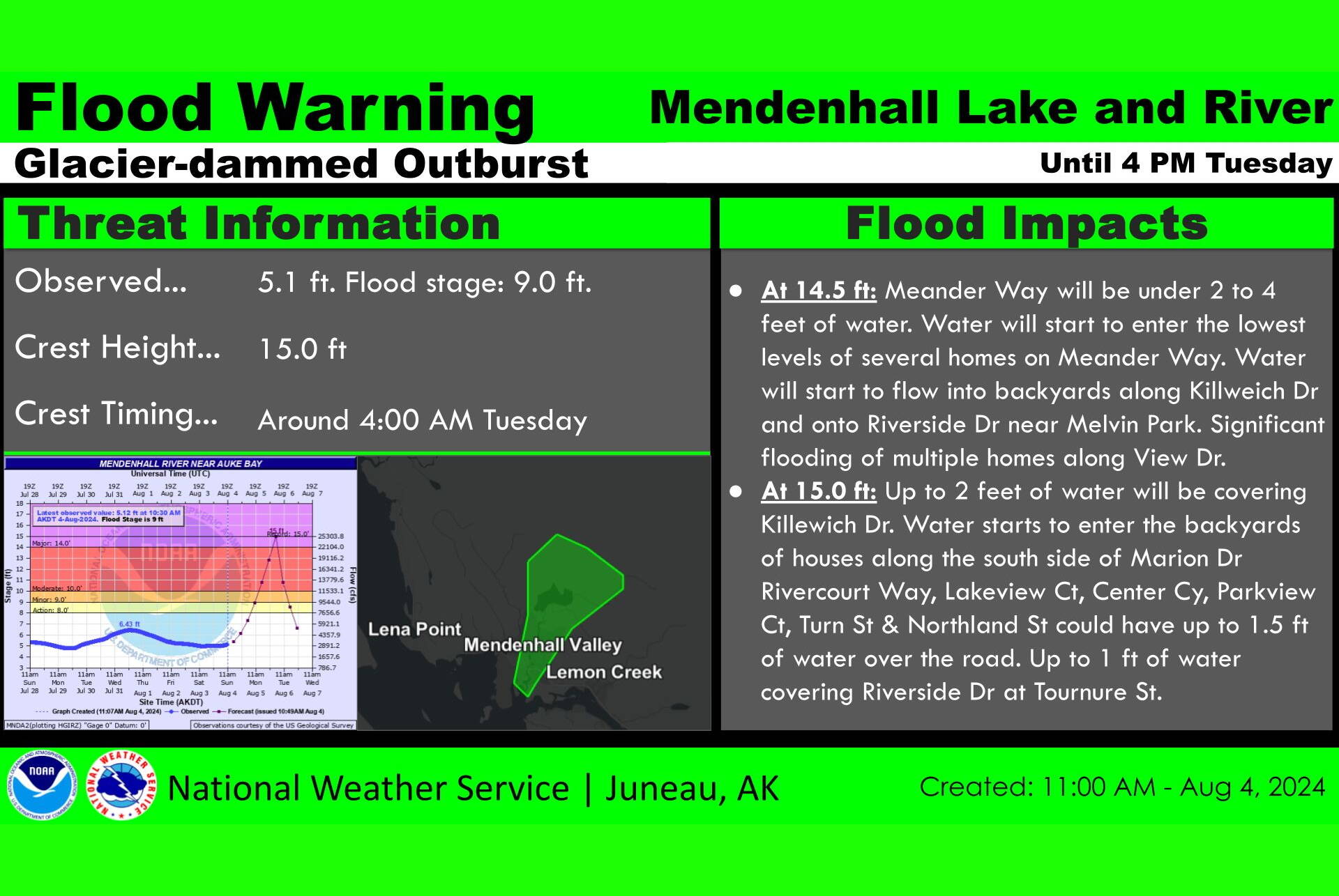
A break of Suicide Basin’s ice dam occurred at about 10:11 a.m. Sunday, with the Mendenhall River forecast to crest at a near-record level of 14.9 feet early Tuesday morning in a “worse-case scenario,” according to the National Weather Service Juneau.
A flood warning has been issued for the area downward from the Mendenhall Glacier, said Nathan Compton, a NWS Juneau meteorologist. The forecasted peak river level “is based on the curve last year.”
“It is pretty much exactly as we estimated from last year,” he said. “It’s going to be updated as we’re monitoring how fast this will be releasing and we’ll be able to edit it as more information becomes available.”
The NWS Juneau’s monitoring website for Suicide Basin issued an update at 10:30 a.m. stating “the Mendenhall River is currently at 5ft with the official forecast crest reaching near record values of 14.9ft by the early morning hours of Tuesday, August 6th. The forecast reflects a near 100% release, similar to the 2023 event.”
The forecast reflects a “worst-case scenario,” said Andrew Park, a meteorologist at the NWS Juneau station.
“We don’t know if it’s going to be a full release,” he said. “All we can do is assume it’s going to be a full release because that’s the worst-case scenario. It could be a partial release. It could slowly drain over whatever time frame.”
A flood warning posted on NWS Juneau’s Facebook page states water levels are expected to surpass the minor flood stage of nine feet at 10 a.m. Monday, moderate flood stage of 10 feet on Monday afternoon and major flood stage of 14 feet on Monday night. The water level is expected to crest at about 4 a.m. Tuesday.
The monitoring website lists the following potential impacts for river levels:
• “15 feet – Up to 2 feet of water will be covering Killewich Dr. Water starts to enter the backyards of houses along the south side of Marion Dr. Rivercourt Way, Lakeview Ct, Center Ct, Parkview Ct, Turn St & Northland St could have up to 1.5 feet of water over the road. Up to 1 foot of water covering Riverside Dr at Tournure St.”
• “12 feet – Water starts to back up between Riverside Dr at Tournure St and Mendenhall River School. Significant bank erosion along unreinforced river banks.”
• “10 feet – Water levels will inundate Mendenhall Campground with up to 3 feet of water covering low areas as well as up to 1.5 feet of water covering Skaters Cabin Road. Portions of West Glacier Trail will be impassable.”
• “6.7 feet – Nugget Falls trail begins to flood near the “causeway” at the end of the trail.”
A bulletin issued by the City and Borough of Juneau advises people to “avoid the Mendenhall River for the safety of yourself and others until further notice.”
“Residents in the vicinity of the river, especially those to the west of Riverside Drive, are strongly encouraged to make an evacuation plan and prepare a go-bag in case of emergency,” the notice states. It adds “if the river appears to be approaching flood levels, CBJ will work with CCFR and JPD to alert residents in the area and issue evacuation warnings if necessary. CBJ is prepared to open sheltering services in the event of a major flood.”
Information about preparation and safety is available at juneau.org/emergency/juneau-hazards. Questions and non-emergency reports can be sent to floodresponse@juneau.gov.
• Contact Mark Sabbatini at mark.sabbatini@juneauempire.com or (907) 957-2306.
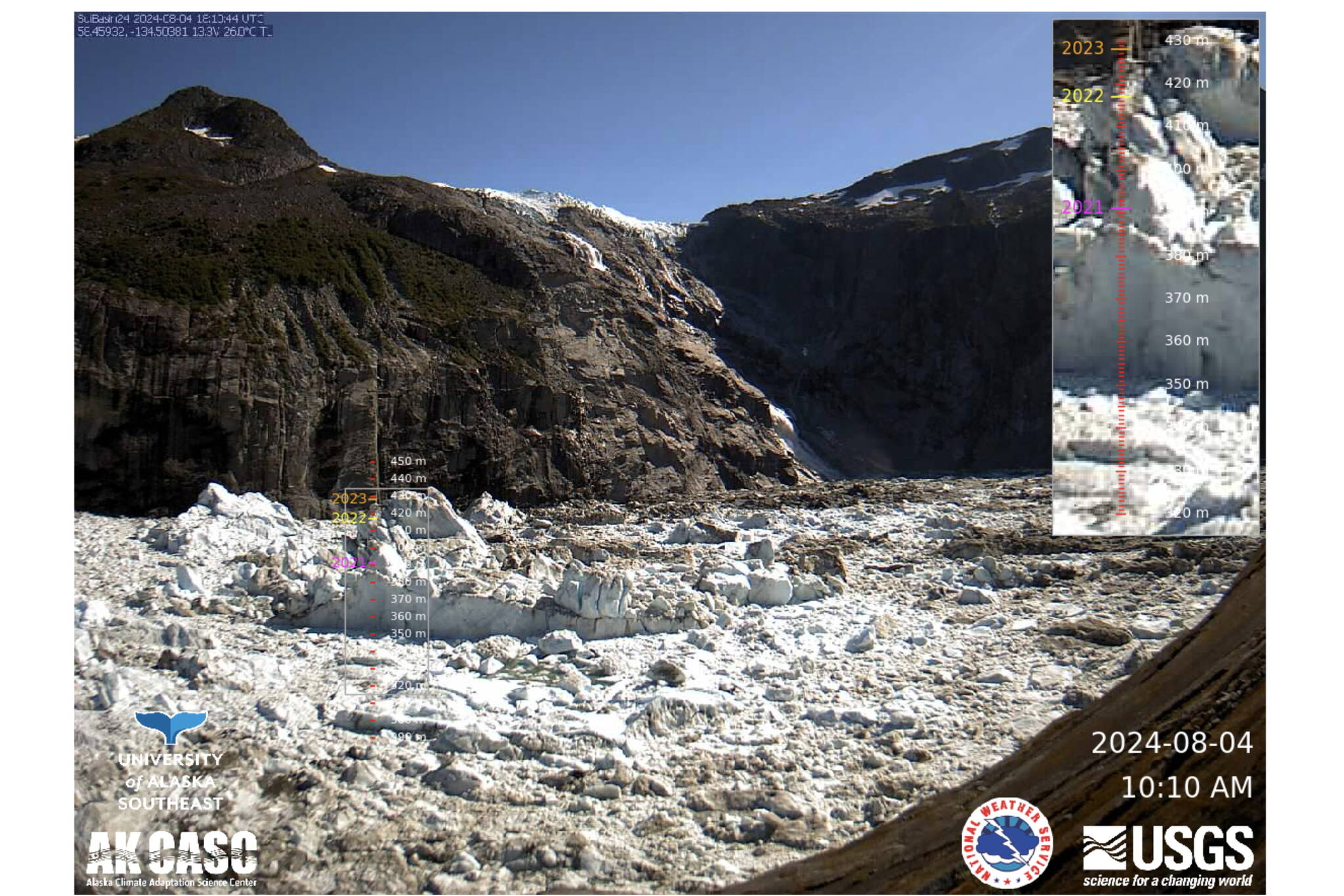
A view of Suicide Basin at the National Weather Service Juneau’s monitoring website just before the ice dam broke at 10:11 a.m. on Sunday. (National Weather Service Juneau)
