String of alarm-clock earthquakes awakens northern Southeast and the Yukon
Published 12:44 pm Monday, May 1, 2017


A series of moderate earthquakes rocked Juneau awake early Monday morning, but no significant damage was reported and no tsunami warning was issued.
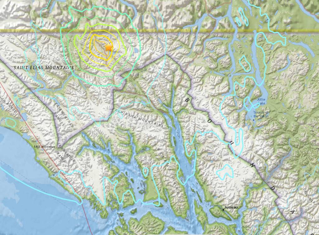
According to the U.S. Geological Survey’s preliminary estimates, the first temblor was a magnitude 6.2 quake that occurred at 4:31 a.m. and was centered along the Haines Highway in British Columbia, between Haines Junction in the Yukon and Haines in Alaska.
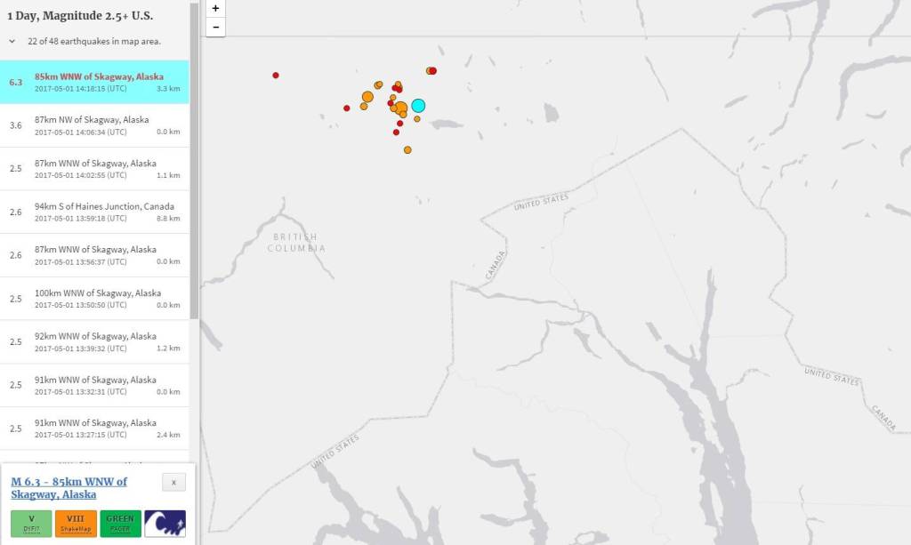
Subsequent quakes followed in the Tatshenshini-Alsek Provincial Park area, the sliver of British Columbia between Southeast Alaska and the Yukon. The largest had a preliminary magnitude of 6.3 and happened at 6:18 a.m. A magnitude 5.2 quake was recorded at 4:49 a.m., and there have been more than two dozen temblors with magnitudes between 2.5 and 4.5. All were relatively close to the surface.
The National Tsunami Warning Center in Palmer issued a statement three minutes after the first quake, saying a tsunami was not expected. That expectation has been repeated after each earthquake.
Earthquake magnitudes and locations may be revised slightly as additional data is processed by seismologists.
The border station at Pleasant Camp is the closest settlement to the epicenter, and the U.S. Customs and Border Patrol officer who picked up the phone there at 7 a.m. said there was no damage and no problems.
The National Weather Service office in Juneau said it had no reports of damage, but the meteorologist on duty did feel the shaking.
According to reports filed by observers with the U.S. Geological Survey, shaking was felt across hundreds of miles, from Petersburg to the center of the Yukon. In downtown Whitehorse, the shaking set off alarms in at least one business, and small landslides were also observed from that city’s clay cliffs. Power was briefly disrupted in Whitehorse, according to the CBC, and the Yukon News reported that one building was closed for inspection after the shaking cracked its structure.
Mark McCready, a spokesman for Alaska Power and Telephone, said he wasn’t aware of any issues related to the quake. AP&T provides telecom and electrical service to Haines and Skagway.
Alaska Electric Light and Power spokeswoman Debbie Driscoll said camera inspection revealed no problems with Juneau-area dams, and workers are physically inspecting them to confirm those findings.
At Klondike Gold Rush National Historical Park in Skagway, staff said there was no significant damage, and on Twitter posted a picture of a sign that had slipped one of its two hooks.
Meadow Bailey, a spokeswoman for the Alaska Department of Transportation, said road crews were inspecting roadways and did not yet have a full report.
By email, Yakutat resident Don Bremner said he was awoken by the 4:30 a.m. quake, and the following event two hours later “felt as if you were getting a dizzy spell in slow motion!”
In Skagway, borough clerk Emily Deach said of that city, “As far as I can tell, we came through unscathed.”
The first temblor was a sharp wake-up, she added. “It definitely woke me up, and my kids — of course the first thing I did was to run to make sure they were OK — they just slept through the whole thing.”
In Haines, assistant clerk Alekka Fullerton said some things fell off shelves in her community, but there was no significant damage.
“I know that one of my coworkers lost a couple of wineglasses,” she said.
Fullerton, who lived in Claifornia during the 1989 Loma Prieta earthquake that rattled San Francisco, said she was surprised that Monday’s earthquakes weren’t much weaker than that event, which killed 63 people.
Monday’s events were the strongest to be felt in Southeast Alaska since a magnitude 7.5 earthquake was centered west of Craig on Jan. 4, 2013. A magnitude 6.0 earthquake centered at Palma Bay, near Icy Strait, occurred in July 2014.
Both of those earthquakes came from the offshore Queen Charlotte-Fairweather fault, where the undersea Pacific plate slides northwest against the North American plate. Monday morning’s quakes appeared near the Eastern Denali Fault, which roughly follows the Haines Highway to Haines, then splits into the Chatham Strait Fault and the Coastal Shear Zone near the northern end of Lynn Canal.
Chastity Aiken is a postdoctoral fellow at the University of Texas Institute for Geophysics. In 2015, she was lead author of a scientific paper that examined the Eastern Denali Fault’s behavior during major earthquakes.
“That area is kind of riddled with faults,” she explained.
In the Gulf of Alaska, just offshore of Southeast Alaska, the Pacific Plate is moving the seafloor 55 millimeters per year to the northwest, sliding beneath the North American Plate that underlies Southcentral Alaska.
The Pacific Plate’s movement is shoving the Yakutat Terrane, a smaller (but still vast) piece of tectonic plate northeast, underneath Yakutat. That northeastern movement is forcing the St. Elias Mountains upward, year by year.
If that collision were a front-end car accident, the Eastern Denali Fault ─ on the far side of the mountains ─ would be the portion of the car’s hood closest to the windshield. It’s crumpled by the impact but not directly struck.
Speaking by phone from Texas, Aiken said it appears from initial measurements provided by the USGS that Monday’s earthquakes occurred on a “conjugate fault” of the Eastern Denali, not the main branch.
“It’s pretty typical for magnitude 6 and smaller to occur in that area,” she said, and Monday’s events were on the large side.
Strong earthquakes are unusual in Southeast Alaska, but not rare. Alaska is the most earthquake-prone state in the United States, and the capital region is not immune from shaking. The state’s sparse population and low level of infrastructure can mean even significant earthquakes can be unremarkable. A magnitude 7.9 earthquake hit Yakutat in November 1987. In 1972, a magnitude 7.6 earthquake rattled Sitka and Juneau.
Editor’s Note: This story has been updated nine times since 4:30 a.m., was last updated at 10:45 a.m., and will be further updated as events warrant.
Contact reporter James Brooks at james.k.brooks@juneauempire.com or call 419-7732.