Storm leaves behind 29.3” of snow at airport, avalanche hazards, closed schools and state offices
Published 9:30 pm Monday, January 15, 2024


The final total: 29.3 inches of snow at Juneau International Airport and 33.1 inches at the National Weather Service Juneau station. No, it wasn’t a record — it was the 15th-highest ever for a three-day period in Juneau.
But the storm that hit Friday night and continued with a variety of increasingly wet snow types caused plenty of chaos by sinking boats in harbor, triggering an avalanche that closed Thane Road, and prompting the closure of public schools and state government offices on Tuesday.
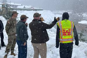
The avalanche Monday evening covered a section of the road south of downtown with about 1.5–2 feet of snow, according to a notice by the City and Borough of Juneau. The road was closed to all but emergency traffic overnight. The Alaska Department of Transportation and Public Facilities stated Tuesday the road will remain closed while cleanup and other work is ongoing.
“Thane Road remains closed due to continued avalanche activity in the region and fallen trees blocking the northbound lane,” a department statement notes. “For the safety of both the public and our crew, the closure will continue until after today’s planned avalanche hazard reduction mission (noon to 2 pm) and subsequent cleanup. We appreciate your patience and understanding – updates will be provided when more information is available.”
A wider avalanche warning has been issued for the mountainous parts of Juneau by Tom Mattice, the city’s emergency programs manager, who stated on his Facebook page Monday evening “it’s crazy deep out there with marginal stability at best.”
Not affected by the storm is the start of this year’s session of the Alaska State Legislature, with the Senate scheduled to gavel in at 11 a.m. and the House at 1 p.m. Several legislators and staff said they encountered no significant problems beyond a few delays.
Helping keep the sidewalks and entryways around the Alaska State Capitol clear on Monday for arriving people and supplies was Jason Skidmore, who said at midday he started at 6 a.m. and was scheduled to remain at work until 4:30 p.m. He had no guess of how much snow in weight he’d shoveled so far.
“Oh boy, it would be an uneducated guess,” he said. “A lot.”
The snow accumulation at the airport between Saturday and Monday was the third-highest for a three-day period in January, said Edward Liske, a NWS Juneau meteorologist, in an interview Tuesday.
“For reference, normal snowfall for the airport for January is 24.5 inches,” he said.
Another extraordinary number was the snow ratio — essentially how fluffy or wet snow is — with a peak ratio of 52, meaning one inch of precipitation would result in 52 inches of snow, Liske said.
“That is a rather rare one to see,” he said.
The high ratio was due to near-zero temperatures just before the storm hit. As temperatures warmed through Monday, the ratio reached a peak density of 14, Liske said.
The Juneau weather service station, in a post on its Facebook page, calculated the 25 inches of snow on the station’s roof equated to 3.3 inches of water, which means about 15 to 20 pounds of weight per square foot.
“Each roof varies, but for a roof with a 35-degree pitch, this would mean a weight of 14.13 to 17 lbs per square foot,” the post adds.
Accumulation in other Southeast communities was uneven, with Gustavus reporting 11 inches by the end of the storm and Pelican 32.5 inches as of 8 a.m. Monday, he said.
The forecast until at least the weekend is dry with temperatures from the mid-20s to about 30, but with Taku winds arriving as early as tonight and lasting until Thursday, Liske said.
• Contact Mark Sabbatini at mark.sabbatini@juneauempire.com or (907) 957-2306.


