How a breakthrough in the Mendenhall River changes erosion near Brotherhood Bridge
Published 6:00 am Thursday, October 18, 2018
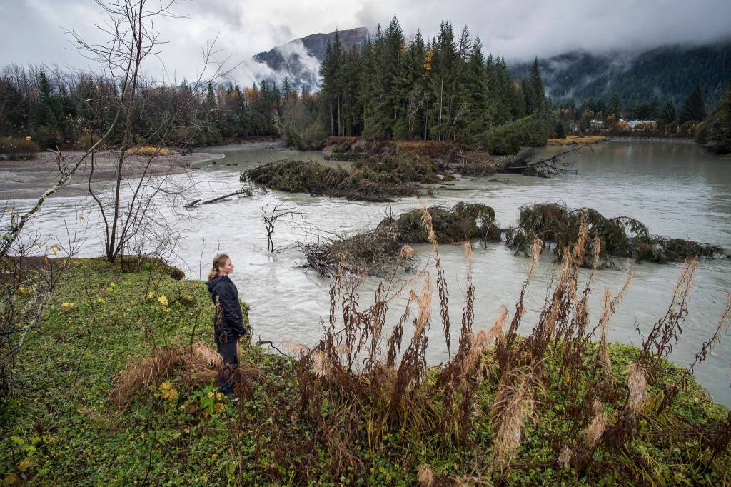
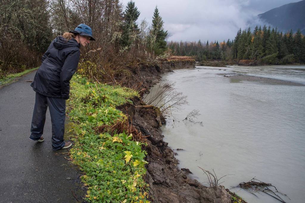


It’s mid-morning at an oxbow on the Mendenhall River, and signs of change are all around.
A handful of spruce trees, felled by river erosion, sit awash in the gray-green rush. Silty ledges, precariously close to falling, lean out over both sides of the riverbank. Signs of an now-abandoned camp — soaked clothes and trash bags — cling to one of these ledges.
Water pushes through a newly-created shortcut. It started with just a trickle after a glacier dam break in July. Since then, that shortcut has widened at a quickening pace, rerouting the Mendenhall River permanently and tracing a new path of erosion on either side of the riverbank.
University of Alaska Southeast professor Sonia Nagorski stands at the river’s edge Wednesday, taking it all in. She’s kept track of the river’s meanderings over the years, but she’s never seen the Mendenhall River like this.
“It’s widening both sides, from my visual estimate. … I think all of this is going to have to be gone,” she said.
Most of the river now pushes through a new path, skipping the oxbow entirely, pushing through what’s called meander neck. The river’s new path has raised concerns for erosion under a local trail on one side, and a business park on the other.
A shortcut
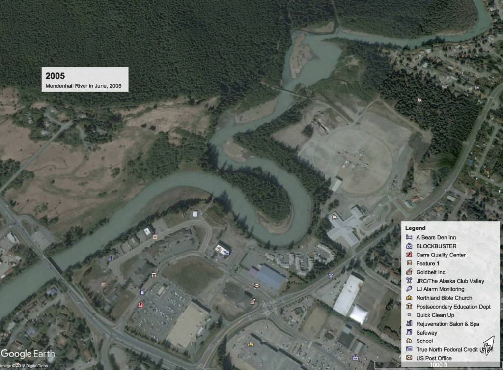
Erosion and deposition work constantly to reshape the Mendenhall River. As the Mendenhall Glacier flows forward, it grinds down rock, creating glacial silt. The river carries that silt and clay and sand, bringing it out to Fritz Cove.
Some of that sediment gets deposited on the way, but the river picks up more in fast water, Nagorski said.
“Places where it’s slow, it piles it up, other places where the river is fast, it picks up some more. It’s this cut and deposition, cut and deposition all the way down,” Nagorski said.
Imagine a hose pointed at a sandcastle. Wherever the hose sprays, sand sloughs off. Likewise, wherever the Mendenhall’s fast water hits a bank, sediments there will be eroded.
That’s what happened to the meander neck. As it turns onto the oxbow by Riverbend Elementary School, water speeds up. Over time, that fast water eats away at the neck.
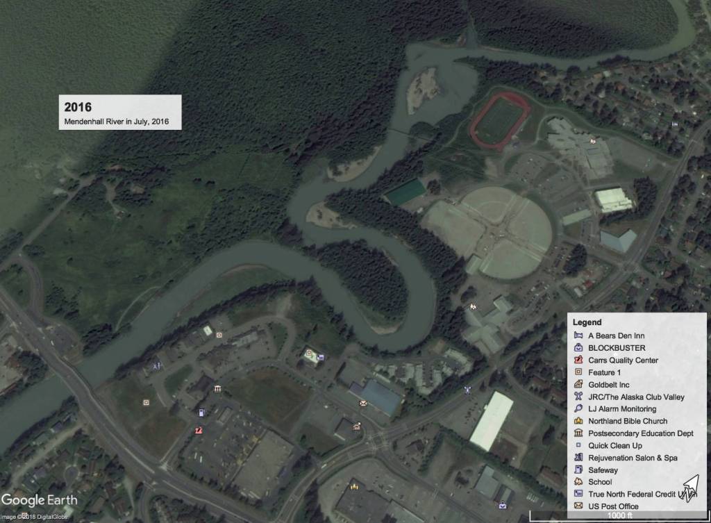
In 1962, according to U.S. Geological Survey maps, the meander neck was as wide as 80 meters. This spring, Nagorski’s class measured the meander neck. It had shrunk to only 1.3 meters.
“My students and I were joking that we could have taken a shovel and just dug it out,” Nagorski said.
She and her students have known the meander neck would eventually break, but nobody knew when. But a jökulhlaup in July officially broke the river’s new path.
It has since grown from a trickle to a full river.
What it could mean
The shortcut cuts out about 2,200 feet of river length from where water enters the oxbow to where the river path straightens, according to a rough estimate on satellite images.
Water on the oxbow has all but crawled to a standstill. Because it’s moving so slow, sediment will drop down to the bottom. That will pile up over time and eventually form a mud flat, Nagorski said.
Grass, moss and eventually trees will likely grow there. Maybe even houses, Nagorski said.
The new route is shorter, but it’s also steeper. Water moves quicker through the shortcut than it did around the oxbow, meaning it will crash into the riverbanks on either side with more force than it did before, Nagorski said.
[Curious by Nature: What is glacial flour?]
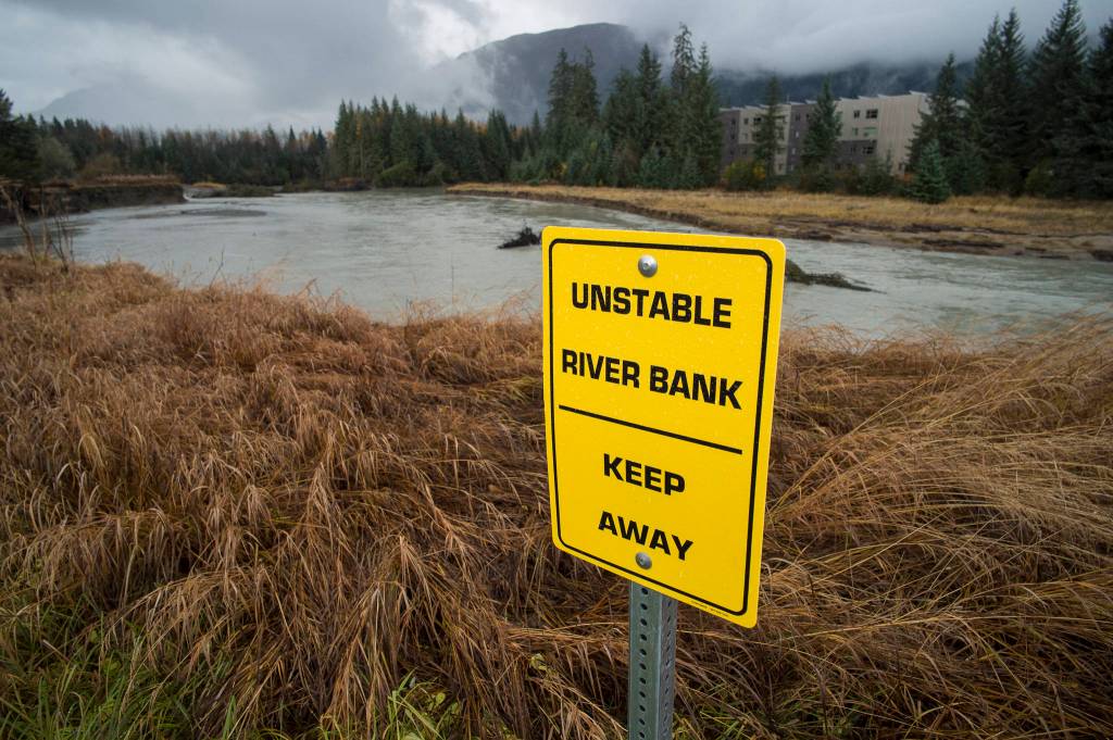
Without close surveys, it’s hard to tell exactly what will happen to both sides of the river. It’s already taken out about anywhere from 10-50 feet of riverbank on the Brotherhood Bridge Trail side of the river.
City and Borough of Juneau Parks and Recreation closed part of the trail down after the Jökulhlaup this summer, trail managers said. (New trail access lies at the end of Wildmeadow Lane.)
CBJ Project Manager Alexandra Pierce said recent rains have been the first high water event since the river changed route. CBJ is observing what the river is doing this fall to inform a safer redesign of Brotherhood Bridge Trail.
“We’re just evaluating how the river is going to behave over the next little while and the ultimate reroute of the trail will be far enough from the bank, probably on the other side of the meadow,” Pierce said.
Engineers are working on the design this winter, and will likely start work next spring, Pierces said.
On the other side of the river from the trail, water flows now point straight at Trillium Landing, a 49-unit senior housing property that opened last year. Erosion is likely to increase on that side of the river.
Managing company Quantum Mangement Services, Inc., said they’re keeping track of how the building might be affected.
“We do have a situation manager there at the building that would keep us posted on any events,” said Trillium Landing’s Doug Repman.
The pinch points for erosion on the river will likely change as the process of erosion and deposition carries on, Nagorski said. That course will be hard to predict.
“What is certain is that it will be changing, and probably be changing for years,” Nagorski said.
• Contact reporter Kevin Gullufsen at 523-2228 and kgullufsen@juneauempire.com. Follow him on Twitter at @KevinGullufsen.