City hopes new interactive map of vacant properties will expand housing opportunities
Published 10:30 pm Thursday, January 19, 2023


Looking to develop housing in Juneau but don’t know where to start? There’s a map for that.
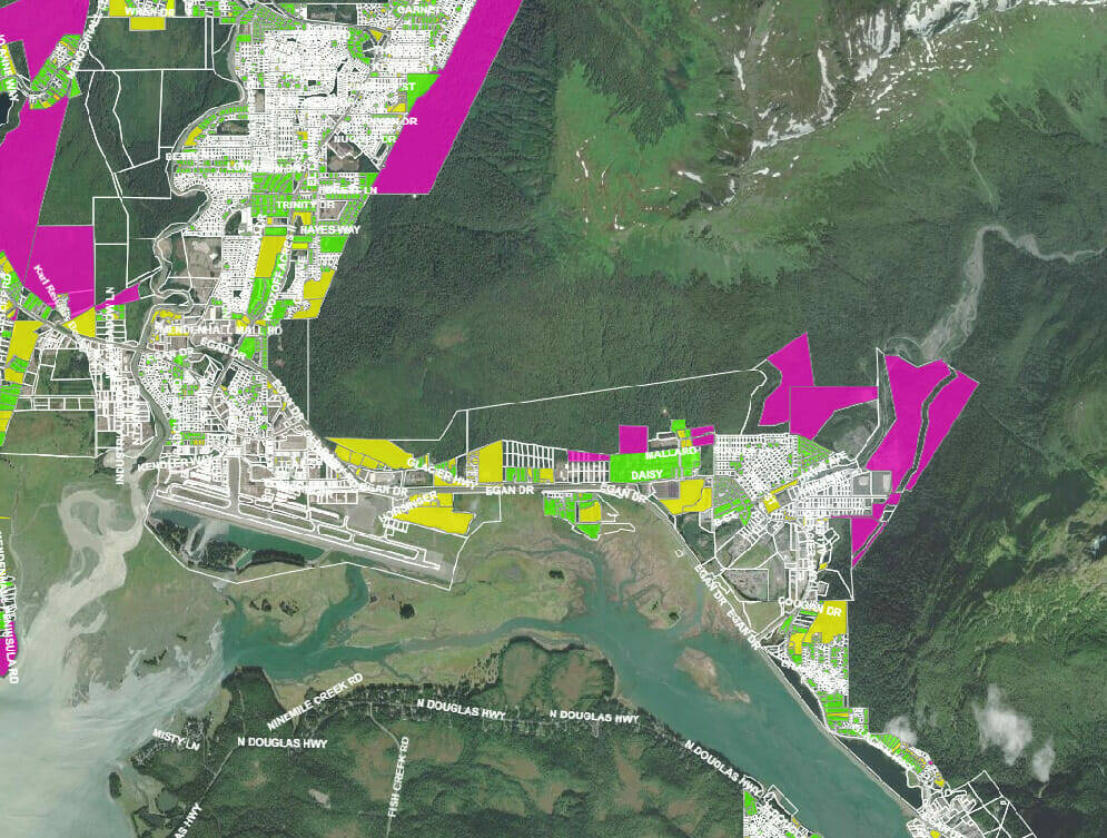
Earlier this week the City and Borough of Juneau’s Community Development Department released an online interactive map that outlines the different pieces of vacant and underdeveloped property in Juneau and offers more information on each parcel by highlighting features, such as its ownership, zoning and potential hazards.
According to Joseph Meyers, the city’s housing and land use specialist, the new map was developed as yet another resource to aid the city’s goal of expanding housing opportunities and to highlight the city’s buildable properties for potential future developments to interested developers or residents.
“What we saw was that there was a gap in information for communicating with the community and developers about the different properties and resources available,” Meyers said. “So, we put our heads together and tried to look at the housing crisis in different ways, and it just made sense to put this together.”
Meyers said all the information included in the mapping was already public information, however, it was scattered in different places online and a lot of it could be difficult to understand without proper context. He said the city hopes this new consolidation of information will encourage future housing development and opportunities across Juneau.
The interactive map was developed by the city’s geographic information system analyst Quinn Tracy over the course of the past month.
“There’s been quite a bit of talk about who owns what and there’s been a lot of discussion about properties and what exists in the vacancy inventory,” Tracy said. “I think it’s important to show parcels that would be costly or difficult and really provide the whole picture.”
The interactive map uses distinct bright colors to distinguish where a piece of property is privately owned, city-owned, or currently developed at a level below the maximum allowable housing density, meaning there could be an opportunity for potential expansion.
Another main feature of the map depicts more context of the individual parcels themselves like their current zoning levels and density, along with hazard risks such as if the parcel is located on wetlands, flood zones, or a steep slope.
Deputy city manager Robert Barr said the idea to create the map was prompted by public comments and by Mayor Beth Weldon who asked for the city to find a way to outline what current parcels in Juneau are potentially developable, including both city-owned and privately owned so that residents and potential developers are more incentivized to search around for opportunities.
“It’s one more tool in the toolbox,” Barr said. “The hope is that the map will help the public look at what’s out there and it’s a way to increase transparency and if developers see city-owned parcels that they think that they can develop, they can then engage with us about that and can also do that in the private sector as well.”
The original draft of the map was shared with the Assembly during its December retreat, and Barr noted that the map will constantly be updated as more information comes, and it might not be 100% accurate. He encouraged residents and developers to reach out to the city if something appears incorrect.
• Contact reporter Clarise Larson at clarise.larson@juneauempire.com or (651)-528-1807. Follow her on Twitter at @clariselarson.