In this screenshot from a video shared Monday by Capital City Fire/Rescue, the waters of Suicide Basin have topped the low point in the dam holding the reservoir and are beginning to flow downhill. (Screenshot)

In this screenshot from a video shared Monday by Capital City Fire/Rescue, the waters of Suicide Basin have topped the low point in the dam holding the reservoir and are beginning to flow downhill. (Screenshot)

Suicide Basin begins releasing water, but flooding risk unknown

Mendenhall Lake levels are declining, not rising

Suicide Basin began its long-awaited release of water late Monday, but there are no signs of incipient flooding along the banks of the Mendenhall River or Mendenhall Lake.

In fact, water levels within the lake and river system dropped Monday and Tuesday following the end of weekend rainfall.

“That’s telling us there is not that much inflow,” said Aaron Jacobs, a hydrologist with the National Weather Service in Juneau. “We’re not putting out any advisories or warnings or watch statements yet because we’re still seeing how this is going to evolve.”

For the past eight years, Suicide Basin, in a side lobe of the Mendenhall Glacier, has been collecting and releasing water with seasonal regularity, occasionally causing minor flooding along the lake and river that share the glacier’s name.

The worst flooding was in 2016, and the scientists who monitor the basin have previously told the Empire that water levels within its reservoir are at or above 2016 levels.

It’s not yet clear whether that means the Valley should expect another summer of high water.

Since it began causing regular floods, the basin has released its water through channels beneath the glacier. Those channels are normally blocked by ice, but when the water pressure within the basin exceeds the strength of the ice, the channels break open, allowing the basin to drain.

This year is different. In late June, an ice shelf more than 1,000 feet long calved into the basin. It was thought at the time that the titanic tumult might jar the channels open. Instead, the ice appears to have sealed the basin more tightly. With the subglacial channels blocked, the basin has filled to the point that it now tops the dam holding water within the basin.

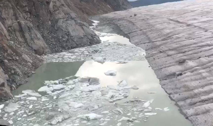
Late Monday, the basin’s water began flowing over the dam and downhill, along the boundary between the glacier and the eastern rock wall that defines its border.

A helicopter video shared by Capital City Fire/Rescue on Monday (embedded below) shows that flow disappearing into the glacier after traveling several thousand feet downhill. In prior years, it has taken several days for water released from the basin to begin affecting the level of Mendenhall Lake and River. It is not clear whether this different avenue will also take several days to show effects.

In addition, it is not clear how quickly water will be released from the basin via this new channel. The flow of water over the dam is expected to gradually erode it, allowing more water to flow out of the basin.

“It’s too early to tell how this is going to evolve,” Jacobs said.


• Contact reporter James Brooks at jbrooks@juneauempire.com or 523-2258.


More in Home

Capital City Fire/Rescue completes last season’s ice break rescue training at the float pond near Juneau International Airport. (photo courtesy of Capital City Fire/Rescue)
On thin ice: Fire department responds to season’s first rescue at Mendenhall Lake

This week’s single digit temperatures have prompted dangerous ice ventures.

Downtown Juneau experiences its first significant city-level snow fall of the season as pictured on Saturday, Dec. 6, 2025. (Mari Kanagy / Juneau Empire)
Sub-zero temperatures to follow record snowfall in Juneau

The National Weather Service warns of dangerous wind chills as low as -15 degrees early this week.

Brenda Schwartz-Yeager gestures to her artwork on display at Annie Kaill’s Gallery Gifts and Framing during the 2025 Gallery Walk on Friday, Dec. 5. (Mari Kanagy / Juneau Empire)
Alaska artist splashes nautical charts with sea life

Gallery Walk draws crowds to downtown studios and shops.

A truck rumbles down a road at the Greens Creek mine. The mining industry offers some of Juneau’s highest paying jobs, according to Juneau Economic Development’s 2025 Economic Indicator’s Report. (Hecla Greens Creek Mine photo)
Juneau’s economic picture: Strong industries, shrinking population

JEDC’s 2025 Economic Indicators Report is out.

Map showing approximate location of a 7.0-magnitude earthquake on Saturday, Dec. 6, 2025. (Courtesy/Earthquakes Canada)
7.0-magnitude earthquake hits Yukon/Alaska border

Earthquake occurred about 55 miles from Yakutat

Gustavus author Kim Heacox talked about the role of storytelling in communicating climate change to a group of about 100 people at <strong>Ḵ</strong>unéix<strong>̱</strong> Hídi Northern Light United Church on Wednesday, Dec. 3, 2025. (Mari Kanagy / Juneau Empire)
Author calls for climate storytelling in Juneau talk

Kim Heacox reflects on what we’ve long known and how we speak of it.

The Juneau road system ends at Cascade Point in Berners Bay, as shown in a May 2006 photo. (Michael Penn / Juneau Empire file)
State starts engineering for power at proposed Cascade Point ferry terminal

DOT says the contract for electrical planning is not a commitment to construct the terminal.

A cruise ship, with several orange lifeboats visible, is docked in downtown Juneau. (Laurie Craig / Juneau Empire file photo)
CBJ seeks input on uses for marine passenger fees

Public comment period is open for the month of December.

Most Read