
A sign on Nugget Falls Trail warns trail users of effects from a flood this week, brought by a storm which has dropped 1-3 inches of rainfall in the Juneau area.
“Mendenhall Lake is flooding and hazards may soon exist along trails beyond this point,” it reads, the words “may soon” covered in yellow tape.
Flood effects from this week’s storm are already here, and more rain is expected Thursday. The National Weather Service predicts the storm will drop 3-5 total inches of rain for the Juneau area.
Water levels on the already fast-moving Mendenhall River are expected to peak at about noon Thursday, according to NWS meteorologists. The service’s Juneau office, which monitors a stream gauge on the Mendenhall River, issued a flood warning Wednesday morning. High water is expected to crest at about at 10.1 feet. Anything over 9 feet is considered a flood, said NWS Meteorologist David Levin.
“We’re expecting that [water levels] to continue to rise through tonight [Wednesday] and crest just above moderate flood stage at 10.1 feet very close to noon on Thursday,” Levin told the Empire in a Wednesday phone interview.
A dry spell in late July actually contributed to the Mendenhall’s flooding, Levin said. Heavy rainfall may have pushed the Mendenhall into flood levels, but large amounts of melt water had already tipped the scales. A few weeks of sunny weather melted snow and ice high in the watershed, swelling the lake and prepping it for this week’s flood.
[Sunshine gives way to a soggy (and potentially record-breaking) week]
Levin said an outpour from Suicide Basin, known as a jökulhlaup, could contribute to flooding. If it did, it wouldn’t be a large factor, he said. Much of the water drained out of Suicide Basin in a jökulhlaup earlier this year.
City and Borough of Juneau Emergency Programs Director Tom Mattice said he spent Wednesday coordinating with city and federal agencies to prepare for the flood. The U.S. Forest Service prepared to evacuate campers at Mendenhall Campground. Forest Service officials at the Mendenhall Glacier Recreation Area dealt with a crowded lump of bears and visitors, both displaced by water levels on Mendenhall Lake. CBJ Docks and Harbors issued a warning for vessel owners.
It’s not the amount of rain that will cause problems, Mattice said, it’s what the rain brings. The 2-3 inches of rain forecast for Wednesday evening and Thursday will increase the risk of mudslides, which are notoriously hard to predict. Rain will loosen soils on mountainsides. If wind picks up, that might rattle trees above, increasing the risk of mudslides as the forest sways.
The NWS recorded a south wind around 35 mph as of Wednesday afternoon. Mattice said owners of mountainside properties should be aware of the risk and have an emergency plan in place.
“When we see two-plus inches of rain a day we start getting to the threshold where we see mudslides, and this forecast is right in there,” Mattice said.
Outside of the risk for mudslides, Mattice said Juneauites shouldn’t be alarmed as this isn’t a big flood and responding agencies are all prepared to deal with heavy rain. If the 10.1-foot forecast comes to fruition, it’ll be the 11th-highest recorded water level on the river, according to NWS data.
But six of those 11 floods have all come from jökulhlaups, glacial dam bursts that are becoming an annual event in Juneau. A jökulhlaup earlier this year caused the Mendenhall to swell to 10.9 feet.
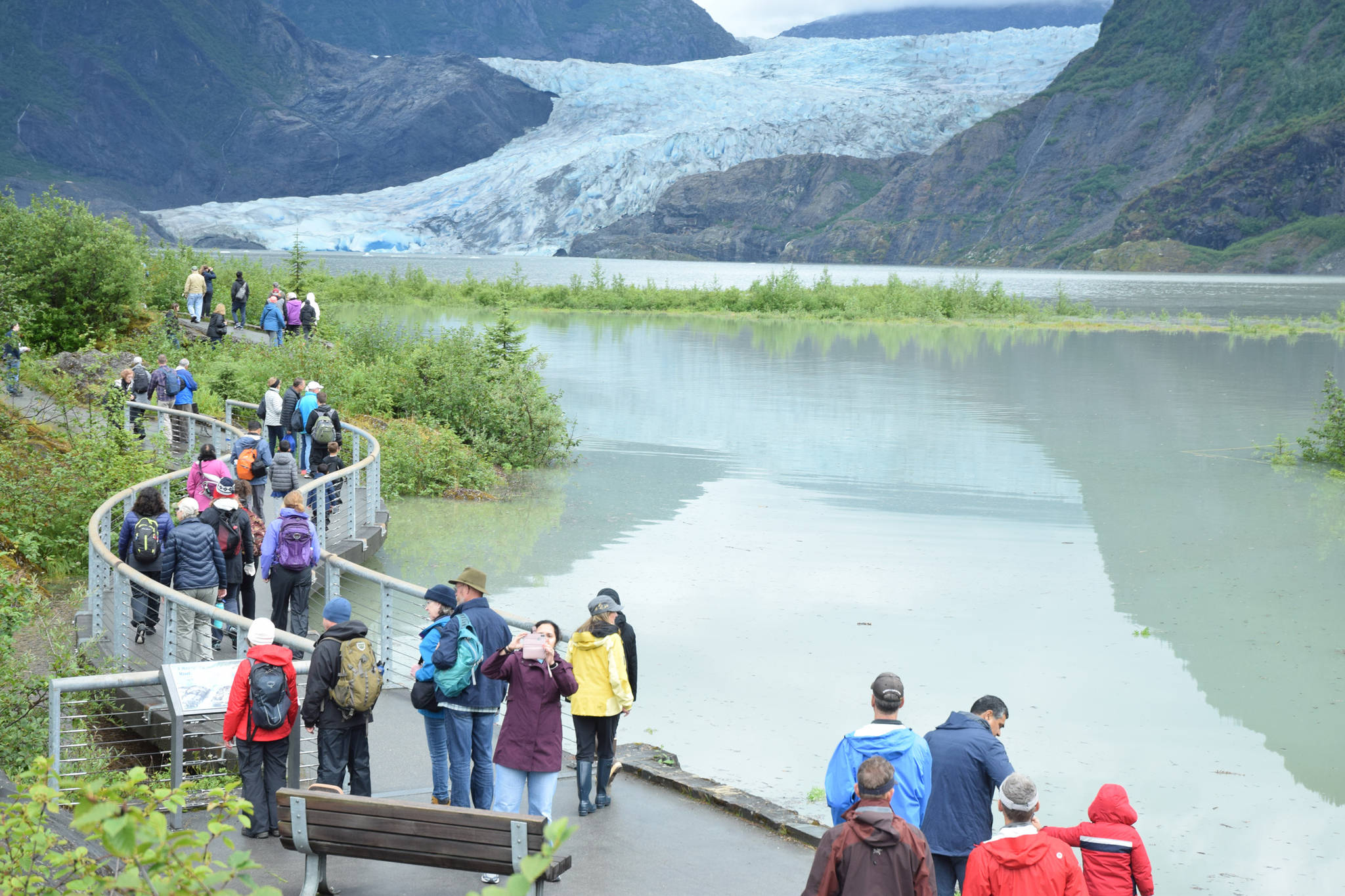
Crowding has become an issue at the Mendenhall Glacier Recreation Area and Visitor Center, said Director John Neary. Nugget Falls Trail, a popular trail which leads throngs of cruise ship visitors to a waterfall close to the glacier, isn’t closed, but it’s impassible after about a quarter mile.
The flooding means more people are congregating at Steep Creek Trail. But so are bears, chasing salmon into shallower water, Neary said. Salmon can elude bears more easily in deeper water. As water levels rise, bears have been pushed away from the lake, closer to the crowded platforms. Beaver dams have also been flooded in the area.
“The fish have plenty of options to escape bears when its 1, 2, 3 feet deep,” Neary said. He asked locals to keep their dogs on leashes when visiting the glacier area. Directing traffic and managing the crowded area becomes a bigger burden with loose canines in close proximity to bears.
Ed Grossman, USFS Recreation Program Manager for the Juneau Ranger District, made the call to evacuate the 70-site tent and RV Mendenhall Campground on the west side of the lake at 3:30 p.m. Wednesday. The campground’s occupancy is light, Grossman said, but they aren’t taking chances with a 10-foot water level, which would flood all but the highest parts of the campground, stranding campers on small islands. The school district has opened restrooms at Floyd Dryden Middle School and has agreed to allow campers to stay there.
West Glacier Road was closed Wednesday afternoon, Grossman said. He asked people to stay away from Skaters Cabin Road and to stay out of the area.
“We don’t want people being isolated in there,” Grossman said.
CBJ Docks and Harbors has asked vessel owners to prepare boats for heavy rain and winds. Harbormaster Dave Borg said in addition to rain, they’re experiencing 40-mile per hour winds all around the Juneau harbor system. Vessel owners should check mooring lines and bilge pumps and make sure everything on board is secured for wind. A small craft advisory is in place for the storm, and Borg encouraged anyone boating during the storm to be careful.
• Contact reporter Kevin Gullufsen at 523-2228 and kgullufsen@juneauempire.com. Follow him on Twitter at @KevinGullufsen.
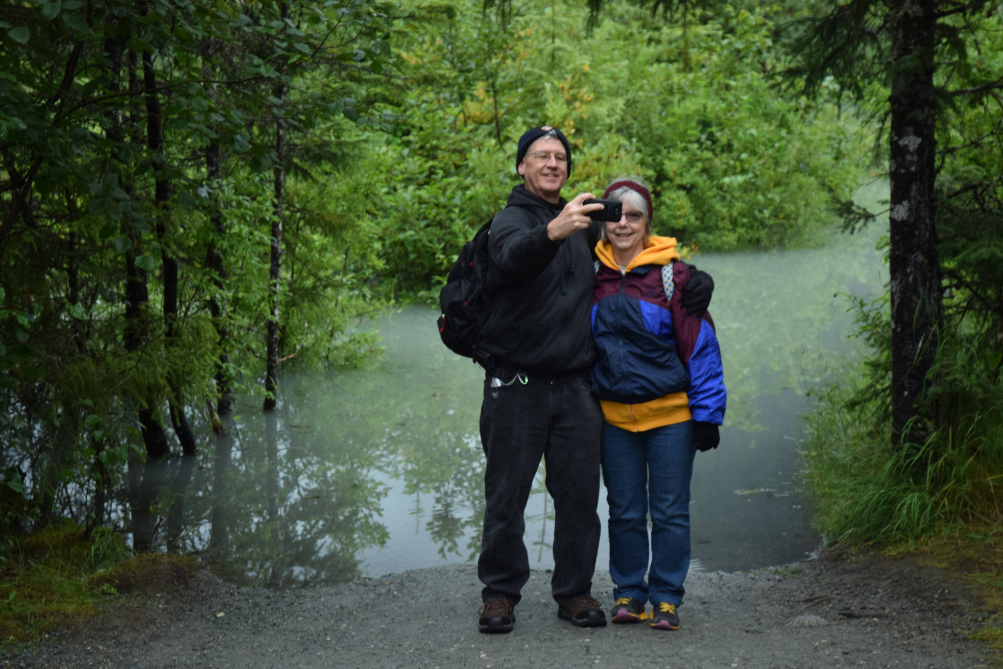
Steve and JoAnne Zemanek, from Dayton, Ohio, pose for selfie at a flooded impass on Nugget Falls Trail. Flooding on the Mendenhall River and lake is expected to peak today. (Kevin Gullufsen | Juneau Empire)
