
By Mary Catharine Martin
Each year, my partner, Bjorn, and I take a river trip. Parenthood (we have a 2-year-old and a 5-month-old) has also meant that we’re also thinking low-key. COVID meant we were dreaming of travel.
So it felt pretty natural, earlier this year, to find ourselves talking about the Stikine — the fastest free-flowing navigable river in North America, which has its start in the Sacred Headwaters of the Klappan Valley in British Columbia (also the source of the Skeena and the Nass Rivers), then crosses the border and flows into the ocean near Wrangell and Petersburg. In Lingít, the river is named “Shtax’heen,” which translates as silty, cloudy or bitter river, Wrangell-based poet Vivian Faith Prescott has told me.
Here in Alaska, the Stikine delta — the largest delta in North America — is a stopover for tens of thousands of migratory birds. Each fall, Alaskans travel up the Stikine to hunt moose (as do Canadians.) And the Stikine is a vital salmon river, with runs of all five species of Alaska salmon and many other fish besides. Southeast Alaska’s three transboundary rivers — the Taku, Stikine and Unuk — produce 80% of its king salmon.
In short, the Stikine is essential to life in the region, as it has been for thousands of years. It has a deep cultural history as a long-standing trade corridor for the Tlingit and Tahltan Indigenous peoples, whose traditional territories encompass the river (something highlighted by a digital production that was one of my favorite efforts of 2020, “When the Salmon Spoke.”)
If you, too, are dreaming of paddling, fishing on or seeing an international river, it’s hard to do better than the Stikine.
The trip
Six years ago, Bjorn and I floated down the Stikine with a couple of friends — Bjorn’s old fishing boat captain and her son. We all met in Wrangell and then flew over the border to Telegraph Creek, the only permanent town on the river, via small plane.
On the road from more populated areas of British Columbia, cars arrive by driving alongside the “Grand Canyon” of the Stikine — a 45-mile stretch of roaring river tackled only by the most daring and skilled of whitewater kayakers, and by a few tour boats, like the one operated by Jim Leslie and family out of Wrangell — Alaska Waters Inc. The stretch of river below Telegraph Creek, a town of a few hundred home to mostly Tahltan people, is much gentler. There are a few small bumpy sections of river (though that may change with fluctuating water levels) but nothing that required serious know-how.
After we made our way from the airstrip, down through old Telegraph Creek (which, at the time, was blocked by a landslide) and to the water, our first major sight on the river was a rock formation known as “the Three Sisters.” The stretch of river after it was relatively easy to navigate.
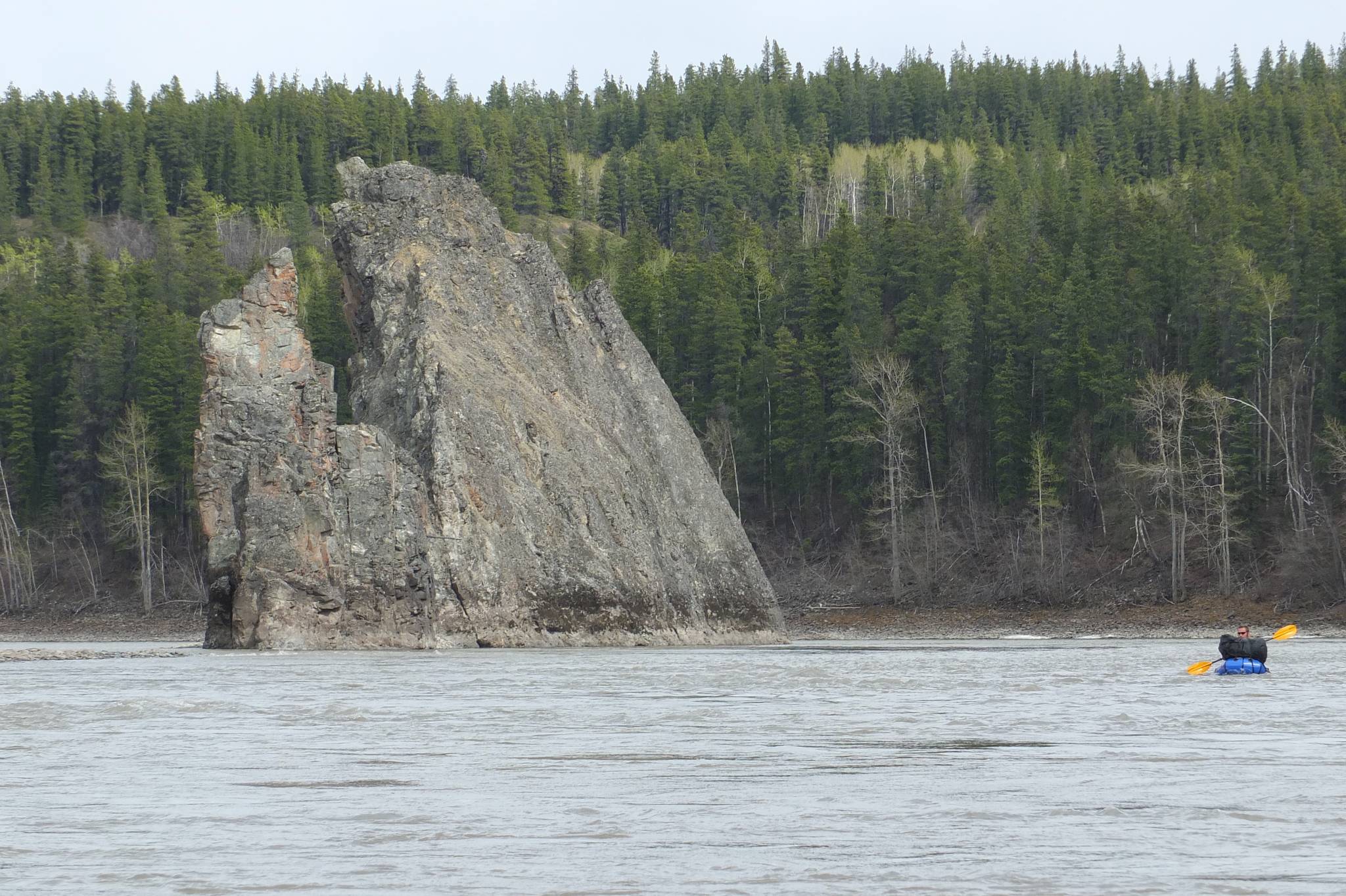
Bjorn Dihle paddles past one of the rock formations known as the “three sisters” just a few miles downstream from Telegraph Creek. (Courtesy Photo / Mary Catharine Martin)
It was early May and stands of birch, poplar and alder trees were just beginning to green up. We watched moose moving along gravel bars — one night a bull woke us when it stamped past our tent and, then, swam across the river. It was easy to get lost in the quiet and wildness of the landscape.
But the Stikine watershed is also the site of vast stretches of mining claims and development. The entire corridor of the Iskut, the Stikine’s largest tributary and one of its most important salmon spawning systems, is covered in claims. Mining isn’t new to the region: What is new is the scale and number of the claims, the amount of waste they would generate and are generating, and the consequences if any of those mine waste dams fail. The Red Chris, one of the largest, is partly owned and operated by Imperial Metals, the company responsible for the 6 billion-gallon Mount Polley mine waste spill in the Fraser River watershed in 2014 — and has the same dam design. Though the causes are manifold — salmon stocks are crashing all over B.C. — since 2014, the Fraser’s famed sockeye run has plummeted.
Back in that sunny May of 2015 on the Stikine, however, we leaned back in our boats, looked up at the blue sky, or watched snow-capped mountains as we floated by at five or six miles an hour. Occasionally, we’d turn our boats to navigate through a choppy stretch of river. We were worried we were floating too fast, so we made sure we had extra time to explore river bars and sit at campfires. One morning we woke and saw the tracks of two wolves that had walked through our camp during the night.
When we were still in Canada we watched three Alaska Department of Fish and Game employees beach seine juvenile Chinook. They aimed to collect 50,000, they said, and tag them with coded wire. King salmon on our transboundary rivers have been suffering in recent years — Unuk Chinook are declared a stock of concern, and the Board of Fish is set to declare Taku and Stikine Chinook stocks of concern as well at its next Southeast-focused meeting in early 2021. Back in November, ADF&G predicted the Stikine would see only 9,900 returning Chinook in 2021.
One afternoon we headed to Fowler Hot Springs, also called Choquette Hot Springs.
We paddled up a calm slough that ended in sandbars, bear and moose tracks, and a faint path over a steep, muddy bank, pulled up our boats and followed along a small creek, testing the water with our hands until it warmed. We saw dozens of small toads, sometimes right where the hot water bubbled up from the sandy ground. Brown bears had been using the warm pools to wallow in.
That evening we camped at the outflow of the Great Glacier and walked up to the glacier itself the next morning.
Crossing the border from Canada into the United States on the Stikine River was the first time I’ve ever seen the lines on a map made manifest. Trees along the line of the border have been clear cut for a width of about ten yards, in straight lines as far as the eye can see.
By this point all of us except for Bjorn, who bathes in ice water beneath the cool light of the moon, were looking forward to Chief Shakes Hot Springs. We surprised a curious brown bear on the banks above us and then turned into a still, almost invisible slough also known as the Ketili River. A few miles later we turned into the shallow slough, just moments after a boatload of screaming people roared out of it at 30 miles an hour. Most people seem to be day visitors from Wrangell, and there aren’t many places to camp. We found a spot for two nights in as high and flat a space as we could.
The hot springs, though, were wonderful. One is indoors, and one is outdoors, looking out onto a meadow filled with sunshine and birds.
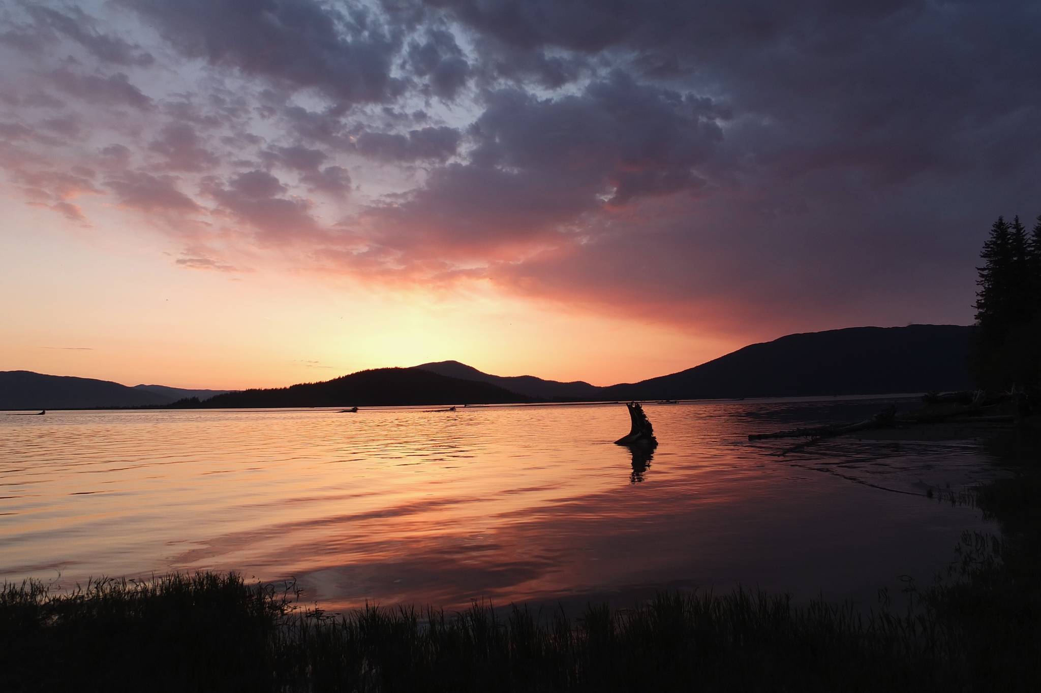
For our last night, we’d booked the Forest Service cabin at Garnet Ledge, a few miles away from Wrangell. We left the hot springs early and paddled out into the miles-long expanse of the Stikine Delta. Arctic terns hovered and dove, yearling seals followed us, and the wind at the mouth of the river blew so hard it was almost impossible to steer a boat filled with air. It calmed as we transitioned to ocean, until the water was like glass. We navigated shallow waters, silt-banks, and driftwood trees whose trunks all pointed just a little to the right of Wrangell. Bjorn and I slowed as we neared the cabin, not wanting the trip to be at an end. That night we watched the most beautiful sunset of the trip, reminisced, and talked about the rivers we plan to float next.
Alaska is home to many rivers, each offering a different journey. The Stikine is one that is truly special. Despite the ever-present yearning to see new things, it’s a river Bjorn and I can’t wait to get back to and share with our children. I hope future generations will have the same chance.
• Mary Catharine Martin is the communications director at SalmonState, an organization that works to keep Alaska a place wild salmon and the people who depend on them thrive. Part of that work is at Salmon Beyond Borders, which works to defend the transboundary Stikine, Taku and Unuk Rivers. To watch “When the Salmon Spoke,” which was presented by Southeast Alaska Indigenous Transboundary Commission and Ping Chong + Company, in collaboration with SkeenaWild Conservation Trust and Salmon Beyond Borders, go to https://vimeo.com/424432430. SalmonState is a free column provided by the namesake organization, which is an advocacy group that works to keep Alaska a place where wild salmon thrive.
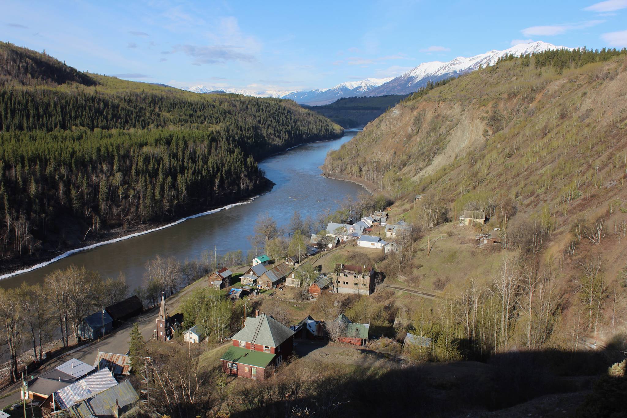
A view of old Telegraph Creek and the Stikine River. Photo by Mary Catharine Martin. (Courtesy Photo / Mary Catharine Martin)
