Local air carrier adopts new tech with aim to make travel in Southeast Alaska safer, more reliable
Published 9:30 pm Sunday, May 5, 2024


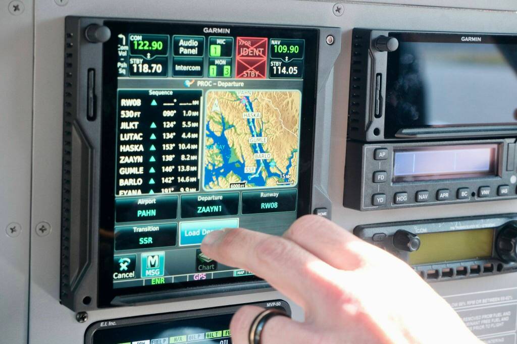


The air was clear and smooth over the Lynn Canal between Juneau and Haines on Thursday, so there was no need to use the new technology installed in the Cessna Grand Caravan’s instrument panel. But when the clouds roll in, as they are forecasted to do next week, the updated avionics will allow pilots to fly this common route through conditions that could typically ground passengers, mail and cargo.
“We put all this in place and then we have had just gorgeous weather,” said Alaska Seaplanes’ Marketing Manager Andy Kline with a laugh.
The company has developed new approach paths and installed GPS equipment to make low visibility flights safer and more reliable.
For people who live in communities like Haines, with no jet or road access, travel in and out is mitigated by the weather and the ferry schedule. The comings and goings of the state’s ferries are so critical that they are announced on the radio with the weather. Locals typically build an extra night into their travel plans to account for canceled flights. “If you want to get there, take the ferry,” is a well-worn piece of travel advice that long-time residents dole out to newcomers.
“We have a goal of being as reliable as the jet,” Kline said of the small plane operator. “We’re not there yet. And even these new approaches don’t get us quite there yet. We’re still going to be on the ground sometimes when the jets are flying.”
To realize that goal, Alaska Seaplanes, the region’s most comprehensive carrier, has developed new approach paths and installed GPS equipment sensitive enough to allow instrument flights even in the challenging geography of the region. Haines, Hoonah, Sitka, Juneau, Kake, Wrangell and Petersburg flights will benefit from the upgrades, which were costly for the small carrier. Flight prices have gone up significantly in the last five years. A disadvantage for small companies is that they must go through the same approvals processes for new routes as major carriers, like Alaska Airlines, which is a time burden on the small staff.
Kline said it has already changed how often flights get out and the conditions travelers experience. “People who’ve flown to Hoonah have never flown through the clouds,’ he said. “So we’re actually having to brief our passengers before they get on board because people get really concerned.”
Most Southeast communities do not have airports with ground control and towers; they have airstrips. Pilots typically fly under a set of regulations designed around high visibility conditions, so they have lower thresholds for getting out in inclement weather. Instrument flights can be employed in low visibility conditions. They rely on GPS technology and Federal Aviation Administration approved flight paths. Seaplanes recently updated nearly all its wheeled aircraft — float planes were not part of the change — and just had its new flight paths approved for use.
A new approach years in the making
Alaska Seaplanes Assistant Chief Pilot Gregg Hake helped explain the changes at a community meeting on Thursday at the Haines library. The route between Juneau and Haines is one of the primary runs out of Juneau.
“How many of you have had a flight canceled?” he asked the crowd.
The room erupted in laughter as every hand went up. “Trick question!” called out former mayor Jan Hill.
Hake said in the week after the upgrades, he flew four flights using instruments that would have otherwise been canceled or delayed.
Flights that use what is called IFR, or instrument flight rules, technology are not new, but the sensitivity of the new equipment and the paths it allows the planes to take are new. Federal approvals took years.
“When you don’t have visual recognition in the clouds, it’s flying you on a very specific approach that keeps you away from mountains and keeps you at the right altitude and all those things,” Hake explained.
Water and mountains complicate the flight paths in Southeast Alaska. Cooperation is involved, too. Ground control is in Juneau, but the airspace over Haines and much of Southeast Alaska is controlled by a tower in Anchorage.
“The legendary status of Alaska as being a difficult place to fly in comes particularly true here,” he said. “We’re flying between mountains that come straight up out of the water, which complicates things like radio communication, complicates things like GPS reception.”
Hake said pilots are not able to use very many land-based navigational devices because the mountains block the transmission to the airplane.
There are other variables, too. He said magnetism from iron in the Chilkat mountain range can throw a compass 20 degrees off north. Luckily, that does not affect satellite navigation systems.
High visibility is a perk on a flight over seemingly endless icefields and glacier-carved fjords whose silt marbles the deep jade color of the water. But, for people who live here, the option to fly safely in marginal weather is important.
• Claire Stremple is a reporter based in Juneau who got her start in public radio at KHNS in Haines, and then on the health and environment beat at KTOO in Juneau. This article originally appeared online at alaskabeacon.com. Alaska Beacon, an affiliate of States Newsroom, is an independent, nonpartisan news organization focused on connecting Alaskans to their state government..contentHolder .fullwidth iframe {float: none !important;width: 100% !important;border: 0px !important;margin: 0px !important;} figure, .tipContainer, .socContainer, .subscribeShortcodeContainer, .donateContainer {display:none !important;} .youtubeContainer { position: relative; padding-bottom: 56.25%; padding-top: 30px; height: 0; overflow: hidden; margin-bottom:12px; } .youtubeContainer iframe, .video-container object, .video-container embed { position: absolute; top: 0; left: 0; width: 100% !important; height: 100%; margin: 12px 0px !important; } .newsroomSidebar {width:35%;max-width:35%;padding:10px;border-top:solid 2px black;background-color:#d3d3d3;float:right;margin-left:50px;} .snrsInfoboxSubContainer {padding:10px;border-top:solid 2px black;background-color:#d3d3d3;} .halfwidth {float:right;width:50%;max-width:50%;} .indent2Container {margin-left: 1em;margin-bottom:1em; border-left: solid 1px black;padding-left: 2em;} @media only screen and (max-width: 600px) {.newsroomSidebar {max-width:95%;width:95%;margin-left:4%} .halfwidth {float:none;width:100%;max-width:100%;} }