Updated flood-fighting inundation maps show effectiveness of HESCO barriers
Published 9:30 pm Wednesday, May 7, 2025
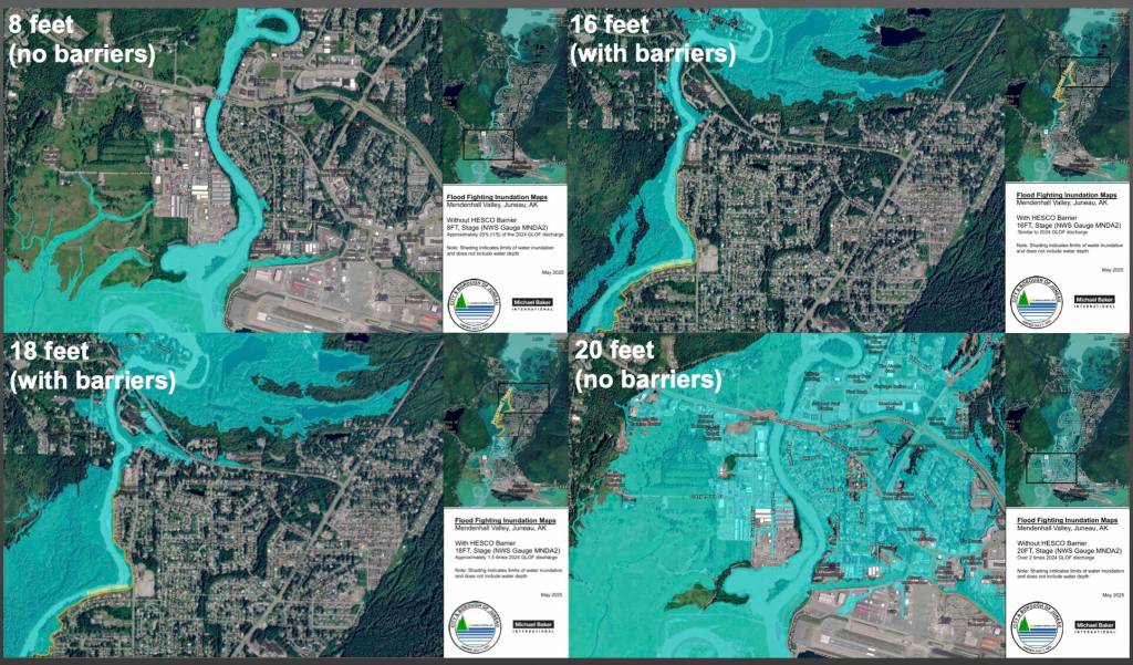


The City and Borough of Juneau released updated flood inundation maps on Thursday that show barriers being installed along the Mendenhall River should protect neighborhoods even at an 18-foot flood level, two feet higher than last year’s record level that damaged hundreds of homes.
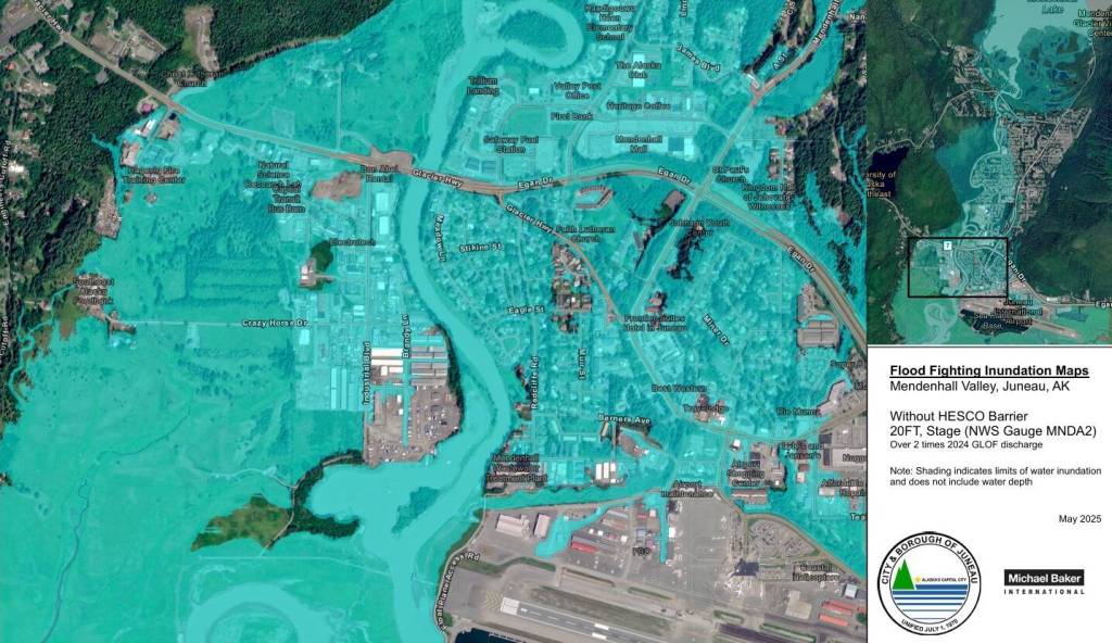
The maps also show possible flooding levels in neighborhoods that previously avoided damage without the controversial barriers. That includes a worst-case scenario where almost all of the Mendenhall Valley is submerged at the 20-foot level. Officials said that would require twice as much water released as last year’s flood and a 200-year atmospheric-river storm event, making it improbable.
National Weather Service Juneau provided the previous flood inundation maps, modeling levels up to 15 feet. At that time, Deputy City Manager Robert Barr said it was considered unrealistic that the flood would reach 16 feet.
But last year, the Mendenhall River broke the 2023 flood record by more than a foot, damaging approximately 290 homes. Barr said that is the reasoning behind the 18-foot and 20-foot conservative model — the city is now erring on the side of caution, however slight the chance. The glacial outburst floods are caused by the break of an ice dam at Suicide Basin — a process known as a jökulhlaup. The releases have occurred annually since 2011 but only recently began severely threatening public safety.
“We would rather find ourselves in a situation where the model makes us over-prepare than under-prepare,” Barr said.
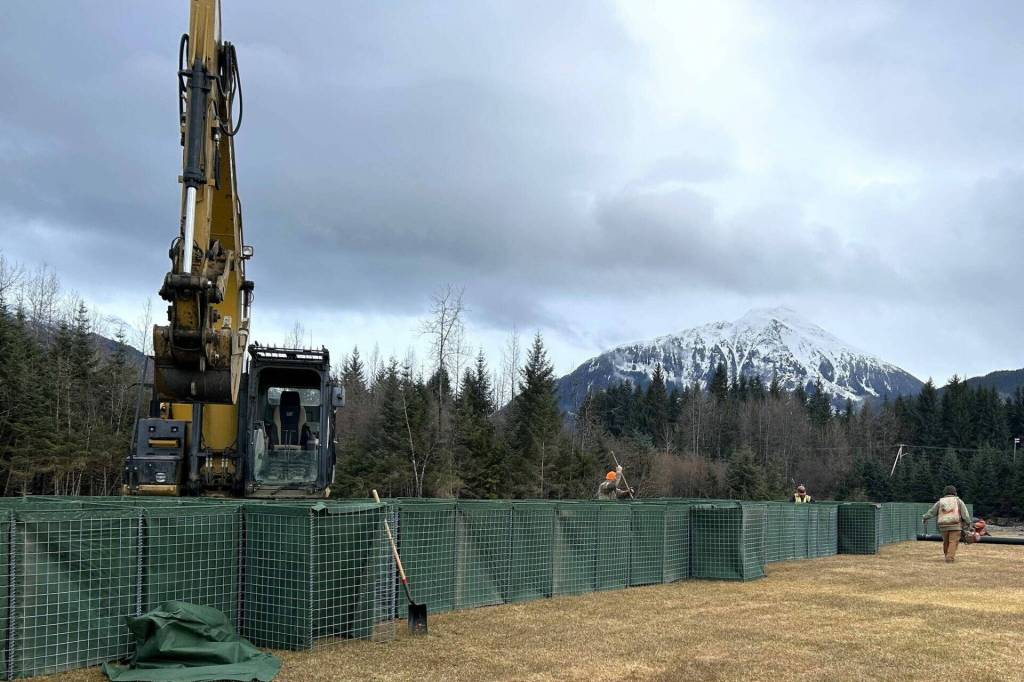
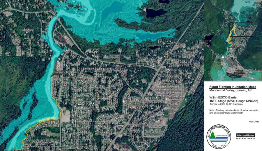
The maps, which model the effectiveness of the Phase One HESCO barrier project, are based on data from last year’s 16-foot glacial outburst flood. The study, conducted by Michael Baker International (MBI), was reviewed by the city, U.S. Geological Survey, U.S. Army Corps of Engineers (USACE), U.S. Coast Guard, National Weather Service, and University of Alaska Southeast. The models show that even up to 18 feet, HESCO barriers should work as intended, protecting the eastern portion of the Mendenhall Valley.
Barr said the barriers do not — and never have — guaranteed safety. The city will still recommend evacuations if a severe flood stage is reached. Last year, children wrapped in towels arrived at the emergency shelter set up at Floyd Dryden Middle School after swimming out of their homes.
Barr said the location of this year’s shelter has yet to be determined.
The maps provide a visual model of eight- to 20-foot flood levels in one-foot increments. The HESCO barriers, recommended by USACE and approved by CBJ on Feb. 3, are expected to be completed by July. The MBI study informed the ongoing barrier alignment and will inform Phase Two, according to city officials.
16-foot model
Since the MBI study considered the topographical changes to the Mendenhall River, the 16-foot flood model without HESCO barriers may show slight differences from the inundation experienced in 2024.
At city meetings before the decision to install the levee, residents worried about how it might impact their downstream and upstream neighbors. The models answer that question.
At 16 feet, the water would be pushed where nobody lives, into a western floodplain and slightly upstream. No impact is shown to commercial or residential areas. According to the model, Phase One of the barriers prevents flooding in residential areas north and south of their placement.
“Even though the HESCOs don’t right now go further south than this point (Rivercourt Way), we still see a lot of protection for the public infrastructure, public property, and the homes south of the current HESCO endpoint,” Barr said.
A question of whether to extend the barriers along CBJ property will be introduced to the Assembly at a special Committee of the Whole meeting at noon on Monday. Another goal of the Monday meeting is to inform the public.
City Manager Katie Koester said the maps show the immediate need for additional short-term flood protection. She said the city is still pursuing long-term mitigation.
“We have the $4.75 million with Army Corps to initiate that feasibility study,” Koester said. “That agreement is underway, so still really focused on that. But again, that will take time, and we just don’t know what the next few years of jökulhlaups will bring.”
She said municipalities do not usually provide flood inundation maps, but CBJ chose to invest to quickly prepare for this year’s release. The maps received funding support from the U.S. Forest Service.
18 and 20-foot models
A video on the new webpage features an explanation by technical experts. One of those experts is a leading researcher of Suicide Basin, UAS environmental professor Eran Hood.
He said an additional website that models flood depths will be released later this month. The 2025 glacial outburst flood inundation maps, built based on the river’s topographical changes, will be factored into the interactive site.
The UAS Juneau Flood website will allow residents in the flood zone to visualize their houses at different depths.
For the Mendenhall River to reach levels of 18 or 20 feet, a combination of variables would have to align in the worst way possible, Hood said. The two biggest factors are flood peak and rainfall.
“It’s a low, very low probability event that’s based on a flood larger than last year that occurs simultaneously with an extremely large rain event,” Hood said.
UAS, National Weather Service Juneau, and the U.S. Geological Survey research Suicide Basin year-round.
The leading scientists have said the Suicide Basin glacial outburst flood is the most researched in the world. The volume of water it can hold is better understood than in 2023, due to UAS drone work. To understand how much water could be released each year, scientists are studying the shape of the basin and how it changes. Experts are still seeking a way to predict how fast it will drain. The upper level of the basin’s capacity is also unknown, and the volume of water becomes difficult to predict as the ice melts.
A five-year study looks at the future of Suicide Basin and its upward flood potential.
“It’s looking to improve the early warning systems we have in terms of our ability to monitor the basin and also to improve our ability to forecast the floods, both on an annual basis and into the future,” Hood said. “Because one of the things we’re most interested in is understanding how much bigger the flood might get if it does get bigger in the future.”
At 18 feet, the HESCOs still protect the eastern side of the Mendenhall Valley, and the upstream and downstream areas where their placement ends.
Many additional properties on the east and west sides of the river would experience flooding, including those that haven’t flooded in the past. In Phase One, the barriers still provide protection at 18 feet, but some water comes up behind them due to where they currently end.
Currently, the 20-foot model only shows what a flood would look like without the barriers. A continued study by MBI aims to demonstrate how the levee functions in this kind of disaster. It submerges almost all of the Mendenhall Valley, flooding the residential area around the airport and making significant portions of Egan Highway impassable.
Koester said she knows it looks scary.
“That’s a valid gut reaction, and then it just has to be checked with what 20 feet really means from a volume of water perspective and the fact that we know so much more now,” she said.
Emergency preparedness
The Central Council of the Tlingit and Haida Indian Tribes of Alaska states it will take a unified command approach with the city this year. The tribe first initiated response and recovery last year.
“What we really learned is that partnerships make things successful, and so working together, we’re stronger,” said Sabrina Grubitz, public safety manager of Tlingit and Haida. “Last year, we learned that this is a big task and it can’t be done alone.”
The Central Council plans to host events in the months leading up to the flood, where people can collect sandbags for their homes and prep go-bags for evacuation.
The tribe will also host a free Community Emergency Response Team training at its Generations Southeast Juneau campus. It will take place on three Saturdays in June: the 14th, 21st, and 28th from 9 a.m. to 4 p.m. Pre-registration is required.
The city urges residents to sign up for the National Flood Insurance Program at floodsmart.gov. The public is also recommended to sign up for alerts. If someone cannot receive alerts on their phone, city officials recommend an emergency weather radio and checking local news. A National Weather Service Juneau Suicide Basin monitoring page shows the status of the basin.
Other preparedness information is available at juneau.org/manager/flood-response and juneau.org/emergency/emergency-flood-response. Questions about the flood modeling maps can be asked at the Monday meeting and directed to floodresponse@juneau.gov.
• Contact Jasz Garrett at jasz.garrett@juneauempire.com or (907) 723-9356.