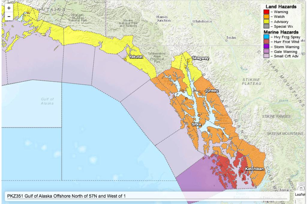
Update: Tsunami advisory canceled for Southeast Alaska
Published 10:30 pm Friday, January 14, 2022


This is a developing story. It has been updated to include additional information.
A tsunami advisory for Southeast Alaska issued following an undersea volcanic erruption was canceled late Saturday morning.
1/15 11:45 AM: The Tsunami Advisory has been cancelled for all of Southeast Alaska. Mariners should continue to expect unusual currents and wave activity for the next few hours. #akwx
— NWS Juneau (@NWSJuneau) January 15, 2022
Scott Langley, senior electronics technician with the National Tsunami Warning Center in Palmer, said waves of less than 3 feet had been reported throughout Alaska, and Southeast Alaska saw significantly smaller waves.
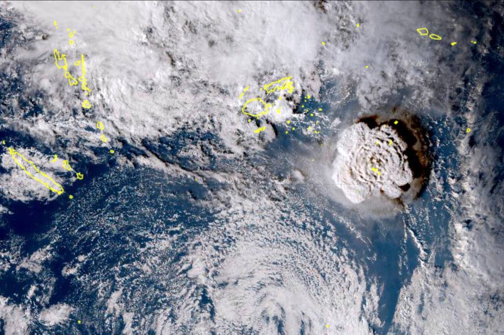
The waves followed an eruption of an underwater volcano near the Pacific nation of Tonga that prompted a tsunami advisory for much of the Pacific.
There were no immediate reports of injuries or on the extent of the damage because all internet connectivity with Tonga was lost at about 6:40 p.m. local time, said Doug Madory, director of internet analysis for the network intelligence firm Kentik.
Tonga gets its internet via an undersea cable from Suva, Fiji, which presumably was damaged. Southern Cross Cable Network, the company that manages the connection, does not know yet “if the cable is cut or just suffering power loss,” chief technical officer Dean Veverka said. He said he assumed the eruption was responsible.
Tonga’s Islands Business news site reported that a convoy of police and military troops evacuated King Tupou VI from his palace near the shore. He was among the many residents who headed for higher ground.
In Hawaii, the Pacific Tsunami Warning Center reported waves that measured half a meter (1.6 feet) in Nawiliwili, Kauai and 80 centimeters (2.7 feet) in Hanalei. The National Weather Service said there were reports of boats getting pushed up in docks, but the hazard diminished as the morning went on.
“We are relieved that there is no reported damage and only minor flooding throughout the islands,” the tsunami center said, describing the situation in Hawaii. The tsunami advisory for the islands was lifted about 11 hours after the eruption more than 4,828 kilometers (3,000 miles) away.
On Tonga, home to about 105,000 people, video posted to social media showed large waves washing ashore in coastal areas, swirling around homes, a church and other buildings. Satellite images showed a huge eruption, with a plume of ash, steam and gas rising like a mushroom above the blue Pacific waters.
New Zealand’s military said it was monitoring the situation and remained on standby, ready to assist if asked.
The Tonga Meteorological Services said a tsunami warning was declared for all of the archipelago, and data from the Pacific tsunami center said waves of 80 centimeters (2.7 feet) were detected.
A Twitter user identified as Dr. Faka’iloatonga Taumoefolau posted video showing waves crashing ashore.
“Can literally hear the volcano eruption, sounds pretty violent,” he wrote, adding in a later post: “Raining ash and tiny pebbles, darkness blanketing the sky.”
The explosion of the Hunga Tonga Hunga Ha’apai volcano was the latest in a series of dramatic eruptions.
Earth imaging company Planet Labs PBC had watched the island in recent days after a new volcanic vent there began erupting in late December.
Satellite images captured by the company show how drastically the volcano had shaped the area, creating a growing island off Tonga.
“The surface area of the island appears to have expanded by nearly 45% due to ashfall,” Planet Labs said days before the latest activity.
Following Saturday’s eruption, residents in Hawaii, Alaska and along the U.S. Pacific coast were advised to move away from the coastline to higher ground and to pay attention to specific instructions from their local emergency management officials, said Dave Snider, tsunami warning coordinator for the National Tsunami Warning Center in Palmer, Alaska.
“We don’t issue an advisory for this length of coastline as we’ve done — I’m not sure when the last time was — but it really isn’t an everyday experience,” Snider said.
He said the waves slamming ashore in Hawaii were just under the criteria for a more serious tsunami warning.
“It looks like everything will stay below the warning level, but it’s difficult to predict because this is a volcanic eruption, and we’re set up to measure earthquake or seismic-driven sea waves,” Snider said.
The first waves to hit the continental United States measured about 30 centimeters (1 foot) in Nikolski and Adak. A wave of about 20 centimeters (.7 feet) was observed in Monterey, California, the U.S. National Tsunami Warning Center said in a tweet.
Beaches and piers were closed across Southern California as a precaution. The National Weather Service tweeted there were “no significant concerns about inundation.” Strong rip currents were possible, however, and officials warned people to stay out of the water.
On California’s central coast, the National Weather Service reported tsunami waves up to 2.5 feet (.76 meters) and flooding in beach parking lots at Port San Luis. About 200 miles (320 km) down the coast, the waves were much smaller at Southern California’s Seal Beach, according to Michael Pless, the owner of M&M Surf School.
“The waves are looking pretty flat,” Pless said. “We’re hoping they reopen the beach in a couple hours.”
Crowds gathered at the Santa Cruz Harbor in California to watch the rising and falling water strain boat ties on docks. Law enforcement tried to clear people away when big surges started at around 7:30 a.m.
About an hour later, a surge went over the back lip of the harbor, filling a parking lot and low-lying streets and setting some cars afloat. In 2011 after the Japanese earthquake a series of surges cost $20 million of damage in the harbor.
Residents of American Samoa were alerted of a tsunami warning by local broadcasters as well as church bells that rang territory-wide Saturday. An outdoor siren warning system was out of service. Those living along the shoreline quickly moved to higher ground.
As night fell, there were no reports of any damage and the Hawaii-based tsunami center canceled the alert.
Authorities in the nearby island nations of Fiji and Samoa also issued warnings, telling people to avoid the shoreline due to strong currents and dangerous waves. In New Zealand, officials warned of possible storm surges from the eruption.
New Zealand’s private forecaster, Weather Watch, tweeted that people as far away as Southland, the country’s southernmost region, reported hearing sonic booms from the eruption. Others reported that many boats were damaged by a tsunami that hit a marina in Whangarei, in the Northland region.
Earlier, the Matangi Tonga news site reported that scientists observed massive explosions, thunder and lightning near the volcano after it started erupting early Friday. Satellite images showed a 5-kilometer (3- mile) -wide plume rising into the air to about 20 kilometers (12 miles).
The Hunga Tonga Hunga Ha’apai volcano is located about 64 kilometers (40 miles) north of the capital, Nuku’alofa. In late 2014 and early 2015, a series of eruptions in the area created a small new island and disrupted international air travel to the Pacific archipelago for several days.
There is not a significant difference between volcanoes underwater and on land, and underwater volcanoes become bigger as they erupt, at some point usually breaching the surface, said Hans Schwaiger, a research geophysicist with the Alaska Volcano Observatory.
With underwater volcanoes, however, the water can add to the explosivity of the eruption as it hits the lava, Schwaiger added.
Before an explosion, there is generally an increase in small local earthquakes at the volcano, but depending on how far it is from land, that may not be felt by residents along the shoreline, Schwaiger said.
In 2019, Tonga lost internet access for nearly two weeks when a fiber-optic cable was severed. The director of the local cable company said at the time that a large ship may have cut the cable by dragging an anchor. Until limited satellite access was restored people couldn’t even make international calls.
Southern Cross Cable Network’s Veverka said limited satellite connections exist between Tonga and other parts of the world but he did not know if they might be affected by power outages.
• Contact Ben Hohenstatt at (907)308-4895 or bhohenstatt@juneauempire.com. Follow him on Twitter at @BenHohenstatt