Suicide Basin outburst prompts evacuation advisory
Published 4:30 am Wednesday, August 12, 2026
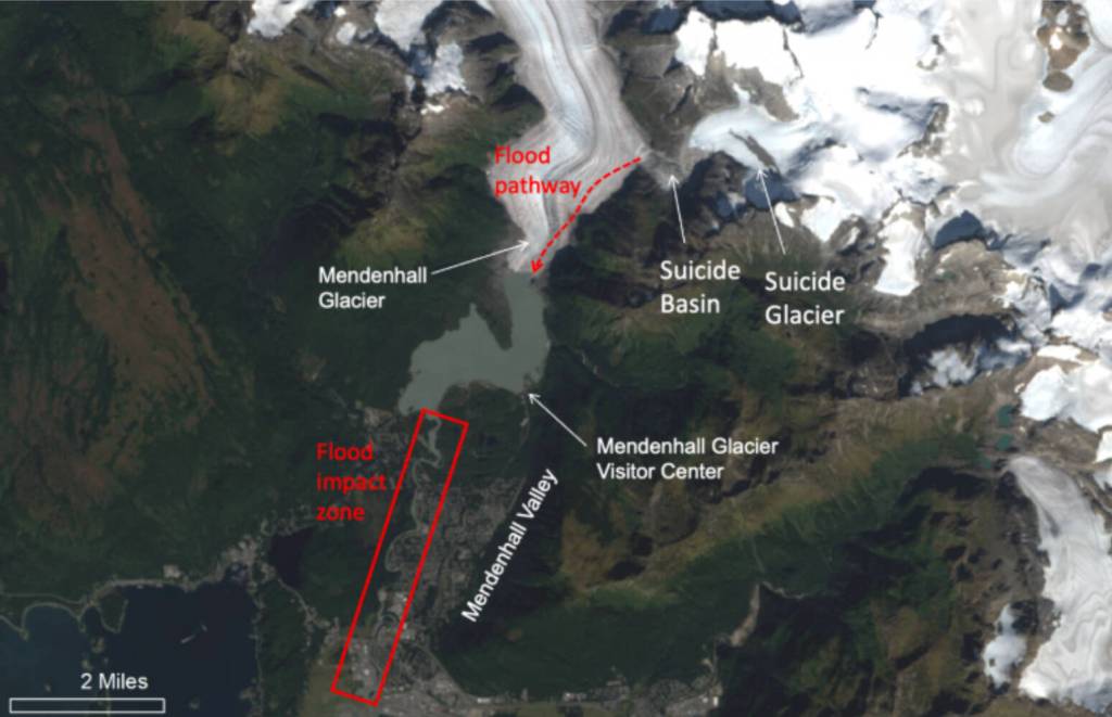
Many Juneau area residents are being urged to evacuate as flooding of the Medenhall River has begun.
A glacial outburst has occurred at Suicide Basin. The basin is releasing and flooding is expected along Mendenhall Lake and River late Wednesday evening into early Thursday morning. The Mendenhall River height was at 5.1 feet and rising at 4 a.m. Aug. 12. A crest between 16.1 and 16.6 feet is expected betwen 5 a.m. and 9 a.m. Thursday. Minor flood stage begins at 9 feet.
Residents are advised to evacuate the mapped evacuation advisory area shown below and at bit.ly/JuneauFloodReady. Officials recommend residents the mapped area evacuate Wednesday and stay until the flood waters recede and an “All Clear” message is communicated via CBJ Alerts and other official channels. Monitor current basin and flood forecasts at https://www.weather.gov/ajk/suicidebasin.
An American Red Cross shelter will be available at Floyd Dryden Gymnasium (3800 Mendenhall Loop Rd.). Visit bit.ly/JuneauFloodReady for more on how and where to evacuate.
The Red Cross will have limited space to shelter pets at the Floyd Dryden emergency shelter. Please read the full requirements and recommendations here. Juneau Animal Rescue (JAR) also offers emergency sheltering for pets through their Safe-Keeping Program (PDF). JAR has created resources to help pet owners prepare for emergencies and evacuation.
Evacuation Routes: To avoid congestion and road or bridge closures, please follow the evacuation routes below described
Residents north of Division Street, please travel north on Riverside Drive, toward Mendenhall (Back) Loop Road and out of the inundation area.
Residents south of Division Street, travel south on Riverside Drive, turn left on Stephen Richards Memorial Drive, towards Mendenhall Loop Road.
On Rivercourt Way, travel south on Riverside Drive, toward Egan Drive
On the west side of the Mendenhall River, travel west on Mendenhall (Back) Loop Road toward Auke Bay (avoid Back Loop Bridge).
West of Brotherhood Bridge, travel west on Glacier Highway toward Auke Bay
Do not go near the river or drive on flooded roads. The barriers provide protection, but flooding remains possible.
If a flash flood occurs, residents in the evacuation will not have time to leave and should shelter in place.
Approaching the river during a flood warning endangers yourself and first responders and interferes with residents evacuating. Find links to watch live footage of the river from the many cameras tracking the flood at bit.ly/JuneauFloodReady.
If you have questions or non-emergency concerns, call the Flood Information Hotline at 907-500-0890 which is now operating 24 hours per day. If you or someone else is experiencing a life safety emergency, call 911 immediately.
Sign up for emergency alerts by visiting bit.ly/CBJAlerts or texting CBJ to 38276. For questions contact the Flood Information Hotline at 907-500-0890 or email floodresponse@juneau.gov.