Landslide maps, emergency system need updating, officials say
Published 12:25 am Sunday, February 25, 2018
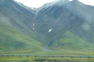
Southeast Alaska is a vertical, rainy place.
Deep glacier-cut fjords give way only to tall, steep mountains blanketed by dense Sitka spruce forests, all of it drenched in seemingly-continual rainfall.
While beautiful, that combination makes the Inside Passage particularly vulnerable to landslides, a natural disaster the city of Juneau, officials say, could be much better prepared for.
Hazard mapping and the city’s emergency alert system both need revamping to prepare Juneau for the eventuality of a landslide, officials from the National Weather Service, the National Oceanic and Atmospheric Association and the City and Borough of Juneau explained at a Friday public lecture at the Mendenhall Glacier Visitor Center.
Work is underway to redo the City and Borough of Juneau’s hazard maps for landslides, something that hasn’t been done since the 1970s. Twenty-first-century mapping and landslide prediction models feed into an alert system, they said, which should be able to alert Juneau residents to landslide hazards in real time.
The city’s old maps, Emergency Programs Manager Tom Mattice said, combine avalanche and landslide hazard mapping. Emergency plannings can’t separate the two out because of this. Changing landscapes and weather patterns also need to be taken into account with updated maps.
“We want to be able to understand hazards better. We want to be able to do that with modern science,” Mattice said.
The new maps will use LiDAR technology, Mattice said, an advanced imaging system that uses light to map landscapes with more precisely than previous technology. It’s expensive and time-consuming work, but Mattice hopes to get started soon mapping the downtown Juneau, a high priority zone because of its population density and vulnerability.
Though we don’t have an accurate picture of where landslides would occur in Juneau, we do know how they happen. They happen in cycles in small depressions in the earth known as bedrock hollows, researcher Adelaide “Di” Johnson, of the National Forest Service’s Pacific Northwest Research Station, explained.
“These hollows are spoon-shaped depressions where woody debris collect. Periodically they fail, usually on a cycle of hundreds or thousands of years,” Johnson explained.
“These hollows are spoon-shaped depressions where woody debris collect. Periodically they fail, usually on a cycle of hundreds of thousands of years,” Johnson explained.
Bedrock is mostly impervious to water, Johnson said, so when it rains, water pools between the soil and bedrock. This can also happen between the soil and a layer of glacial “till,” a finely-packed, cement-like layer of rock deposited by the glaciers which once covered the entire region.
“Water can’t move through the material and collects. The soil becomes supersaturated and basically becomes quicksand on these steep slopes during major rain events,” Johnson said.
The amount of soil in a bedrock or till hollow varies, she explained, but the mean size of a landslide of this type is about 50 dump trucks full. They occur typically on steep slopes after heavy, sustained rainfall.
Landslides in Southeast aren’t easy to predict, but new technology could help, NWS’ Aaron Jacobs explained. Rainfall is the main factor in a landslide he said, and better prediction technology is giving NWS researchers a longer view of precipitation entering northern Southeast.
The NWS gathers weather data from a variety of sources, some hi-tech and others low-tech. Human weather spotters, for instance. New “space-based” satellite mapping is helping the NWS better see what precipitation looks like over the ocean before it hits the Southeast Panhandle.
Satellites add to the NWS’ RADAR data. The technology is improving and getting “better and better” for us, Jacobs said.
“That can tell us a lot of really neat information that we haven’t had before,” Jacobs said, adding, “these space-based satellites can tell us where heavy rainfall is coming at us and we can get a heads up.”
Down the line, emergency managers hope to combine LiDAR maps, predictive models and advanced rainfall forecasting to provide Juneau residents with real-time warning system. Flashing lights could be installed on vulnerable highways and in neighborhoods, NWS’ Joel Curtis said, but whatever the system is, Juneauites will need to be prepared for the inevitability of a landslide.
He encourages people to remember the “six Ps” when prepping for an emergency: people and pets; papers, phone numbers and important documents; prescriptions, vitamins and eyeclasses; pictures and irreplaceable memorabilia; personal computer, hard drive and discs’; and, of course, “plastic,” (credit cards).
If citizens are prepared to get out of a danger zone quickly with everything they need to survive for 36 hours, a warning system doesn’t make much difference, he said.
“A plan and a warning system is no darn good at all if it doesn’t result in positive actions by the people being protected,” Curtis said.
Correction: a previous version of this article said that landslides in Southeast Alaska occur on a cycle of hundreds of thousands of years. They occur on hundreds or thousands of years. The article also stated that Southeast landslides are unique to the area and do not resemble landslides in the Lower 48. Many landslides in Southeast do resemble those in the Pacific Northwest. The article has been updated to reflect the changes.