Scant patches of snow remain at the base of Eaglecrest Ski area on Wednesday despite snowmaking efforts that occurred during the weekend, due to warmer temperatures and rain this week. The opening date for the ski area, originally set for Dec. 2 and then delayed until Dec. 9, is now undetermined. (Photo courtesy of Eaglecrest Ski Area)

Scant patches of snow remain at the base of Eaglecrest Ski area on Wednesday despite snowmaking efforts that occurred during the weekend, due to warmer temperatures and rain this week. The opening date for the ski area, originally set for Dec. 2 and then delayed until Dec. 9, is now undetermined. (Photo courtesy of Eaglecrest Ski Area)

Eaglecrest opening delayed again, target date now TBD

Warm temperatures and rain thwart efforts to open ski area on Saturday.

This story has been updated with newer weather forecast information.

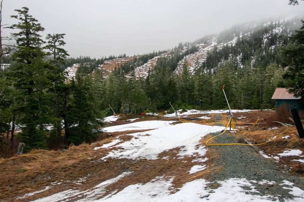
Eaglecrest Ski Area is again being forced to delay its opening due to warm temperatures and rain thwarting snowmaking efforts, with the target date for the start of the season unknown, General Manager Dave Scanlan said Thursday.

The original opening date of Dec. 2 was postponed to this Saturday, Dec. 9, in the hope colder temperatures that set in late last week would allow a sufficient base of natural and man-made snow to be created, Scanlan said. But despite heavy snowmaking efforts last weekend, much of the mountain was again bare by midweek.

“It’s 100% we’re definitely not going to have anything open this weekend,” he said.

But Scanlan said he is hopeful the weather might be more cooperative during the coming days.

“It’s definitely going to be a very active weekend of weather and we’re hoping for the best,” he said. “It looks like none of the forecast models are quite in agreement on how this weekend’s weather is going to shape out as far as where are the temperature’s going to fall and how much snow are we going to get. It definitely looks like there’s a chance that we could get some very significant snowfall this weekend and into the first part of next week.”

The official forecast at the National Weather Service Juneau website as of Thursday morning calls for rain and snow showers in town, with temperatures ranging from the low 40s to about 30. But Pete Boyd, a meteorologist at the station, said Scanlan’s remarks about the uncertainty of conditions are accurate.

“He’s 100% correct about the models being in poor agreement,” Boyd said. “We’ve been seeing massive shifts in the different solutions over the past few days. Even within the short amount of time into the weekend we’re still not seeing great agreement. We do know that a good-sized system is tracking up — a small variation on where the track is can make massive changes in the total precipitation and even what the type of precipitation is for a particular area.”

An updated forecast at about 4 p.m. Thursday offered somewhat more certainty about the weather, but not much in the way of optimism for the ski area opening next weekend. Brian Bezenek, a lead meteorologist at the Juneau weather station, said it appears Eaglecrest could get 27 to 30 inches of snow from a series of storms that each produce several inches during the next few days.

“The bad news is on Tuesday we’ve got a storm coming in that’s warm enough there’s going to be rain,” he said, adding the warm period is like to continue further into the week.

The next open dates on Eaglecrest’s original schedule are a “long weekend” Dec. 15-17 before opening daily during its holiday schedule Dec. 20-Jan. 7 (the ski area will be closed Christmas and New Year’s days). Scanlan said even if an abundance of snowfall occurred this weekend, the ski area couldn’t practically open earlier than those dates.

“Let’s say we get two feet of snow on the ground or three feet of snow on the ground,” he said. “We still have numerous days where the ski patrol has to go out and set up their rope line, mark all the hazards, get all their signage out, and do their avalanche control work.”

“A lot of that can’t happen until we actually get snow on the ground. We’ll be ready to hustle as fast as we can, but it’s just really hard to say. Usually it’ll take us a good three days to get the mountain all set up once we’ve got some snow on the ground to work with.”

• Contact Mark Sabbatini at mark.sabbatini@juneauempire.com or (907) 957-2306.

More in News

A house on Telephone Hill stands on Dec. 22, 2025. (Mari Kanagy / Juneau Empire)
Court sets eviction date for Telephone Hill residents as demolition plans move forward

A lawsuit against the city seeks to reverse evictions and halt demolition is still pending.

Juneauites warm their hands and toast marshmallows around the fire at the “Light the Night" event on winter solstice, on Dec. 21, 2025. (Mari Kanagy / Juneau Empire)
A mile of lights marked Juneau’s darkest day

Two ski teams hosted a luminous winter solstice celebration at Mendenhall Loop.

A Capital City Fire/Rescue truck drives in the Mendenhall Valley in 2023. (Clarise Larson / Juneau Empire file photo)
Juneau man found dead following residential fire

The cause of the fire is still under investigation.

CBJ sign reads “Woodstove burn ban in effect.” (City and Borough of Juneau photo)
Update: CBJ cancels air quality emergency in Mendenhall Valley Sunday morning

The poor air quality was caused by an air inversion, trapping pollutants at lower elevations.

A dusting of snow covers the Ptarmigan chairlift at Eaglecrest Ski Area in December 2024. (Eaglecrest Ski Area photo)
Update: Waterline break forces closure at Eaglecrest Friday, Saturday

The break is the latest hurdle in a challenging opening for Juneau’s city-run ski area this season.

Patrick Sullivan stands by an acid seep on July 15,2023. Sullivan is part of a team of scientists who tested water quality in Kobuk Valley National Park’s Salmon River and its tributaries, where permafrost thaw has caused acid rock drainage. The process is releasing metals that have turned the waters a rusty color. A chapter in the 2025 Arctic Report Card described “rusting rivers” phenomenon. (Photo by Roman Dial/Alaska Pacific University)
Ecosystem shifts, glacial flooding and ‘rusting rivers’ among Alaska impacts in Arctic report

NOAA’s 2025 report comes despite Trump administration cuts to climate science research and projects

The U.S. Capitol in Washington, D.C., on Oct. 1, 2025. (Photo by Jennifer Shutt/States Newsroom)
Moderate US House Republicans join Dems to force vote on extension of health care subsidies

WASHINGTON — Republican leaders in the U.S. House will face a floor… Continue reading

The National Weather Service Juneau issues a high wind warning forDowntown Juneau, Southern Douglas Island and Thane due to increased confidence for Taku Winds this afternoon. (National Weather Service screenshot)
Taku winds and dangerous chills forecast for Juneau

Gusts up to 60 mph and wind chills near minus 15 expected through the weekend.

Chloe Anderson for the Juneau Empire
Fallen trees are pictured by the Mendenhall river on Aug. 15, 2025. Water levels rose by a record-breaking 16.65 feet on the morning of Aug. 13 during a glacial outburst flood.
Lake tap chosen as long-term fix for glacial outburst floods

The U.S. Army Corps of Engineers and Juneau leaders agreed on the plan.

Most Read